
Waremme topographic map
Interactive map
Click on the map to display elevation.
About this map
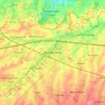
Name: Waremme topographic map, elevation, terrain.
Location: Waremme, Liège, Wallonie, 4300, Belgique (50.65769 5.21462 50.73769 5.29462)
Average elevation: 123 m
Minimum elevation: 82 m
Maximum elevation: 156 m
Other topographic maps
Click on a map to view its topography, its elevation and its terrain.
Petit-Axhe
Belgique > Liège > Waremme > Waremme
Petit-Axhe, Waremme, Liège, Wallonie, 4300, Belgique
Average elevation: 125 m
Bovenistier
Belgique > Liège > Waremme > Waremme
Bovenistier, Waremme, Liège, Wallonie, 4300, Belgique
Average elevation: 139 m