
Thank you for supporting this site ❤️
Make a donation
Make a donation
Hermannsberg topographic map
Click on the map to display elevation.
Thank you for supporting this site ❤️
Make a donation
Make a donation
About this map
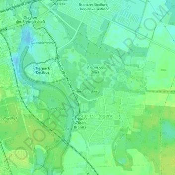
Name: Hermannsberg topographic map, elevation, terrain.
Location: Hermannsberg, Cottbus, Brandenburg, 03042, Deutschland (51.74034 14.36088 51.74044 14.36098)
Average elevation: 76 m
Minimum elevation: 69 m
Maximum elevation: 83 m
Thank you for supporting this site ❤️
Make a donation
Make a donation
Other topographic maps
Click on a map to view its topography, its elevation and its terrain.