
江南区 topographic map
Interactive map
Click on the map to display elevation.
About this map
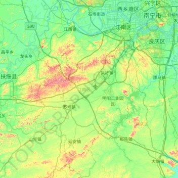
Name: 江南区 topographic map, elevation, terrain.
Location: 江南区, 南宁市, 广西壮族自治区, 中国 (22.33517 107.98126 22.86323 108.34267)
Average elevation: 134 m
Minimum elevation: 48 m
Maximum elevation: 406 m
Other topographic maps
Click on a map to view its topography, its elevation and its terrain.