
Thank you for supporting this site ❤️
Make a donation
Make a donation
Maidenhead topographic map
Click on the map to display elevation.
Thank you for supporting this site ❤️
Make a donation
Make a donation
About this map
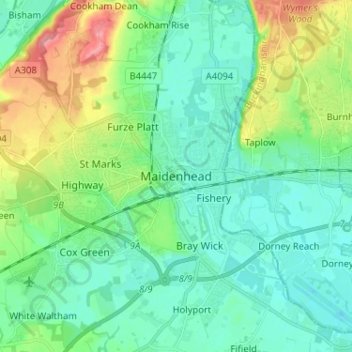
Name: Maidenhead topographic map, elevation, terrain.
Average elevation: 41 m
Minimum elevation: 16 m
Maximum elevation: 113 m
Thank you for supporting this site ❤️
Make a donation
Make a donation
Other topographic maps
Click on a map to view its topography, its elevation and its terrain.
Sunningdale
United Kingdom > England > Royal Borough of Windsor and Maidenhead
Average elevation: 61 m