
Thank you for supporting this site ❤️
Make a donation
Make a donation
Gioux topographic map
Click on the map to display elevation.
Thank you for supporting this site ❤️
Make a donation
Make a donation
About this map
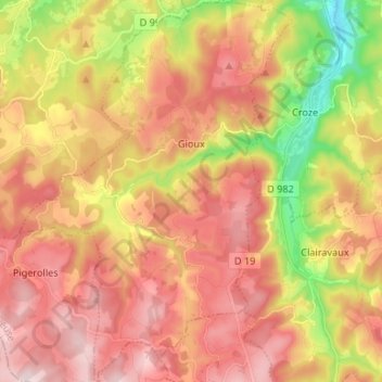
Name: Gioux topographic map, elevation, terrain.
Average elevation: 753 m
Minimum elevation: 537 m
Maximum elevation: 915 m
Thank you for supporting this site ❤️
Make a donation
Make a donation
Other topographic maps
Click on a map to view its topography, its elevation and its terrain.
Puy de la Rode
Frankrijk > Nieuw-Aquitanië > Creuse > Saint-Maurice-près-Crocq
Average elevation: 655 m
Thank you for supporting this site ❤️
Make a donation
Make a donation