
Thank you for supporting this site ❤️
Make a donation
Make a donation
Les Layes topographic map
Click on the map to display elevation.
Thank you for supporting this site ❤️
Make a donation
Make a donation
About this map
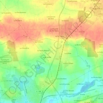
Name: Les Layes topographic map, elevation, terrain.
Average elevation: 84 m
Minimum elevation: 53 m
Maximum elevation: 111 m
Thank you for supporting this site ❤️
Make a donation
Make a donation
Other topographic maps
Click on a map to view its topography, its elevation and its terrain.
Étang de Choisel
France > Pays de la Loire > Loire-Atlantique > Châteaubriant > La Ville Marie
Average elevation: 71 m
Château de Châteaubriant
France > Pays de la Loire > Loire-Atlantique > Châteaubriant > Béré
Average elevation: 73 m