
Thank you for supporting this site ❤️
Make a donation
Make a donation
Jocksdorf topographic map
Click on the map to display elevation.
Thank you for supporting this site ❤️
Make a donation
Make a donation
About this map
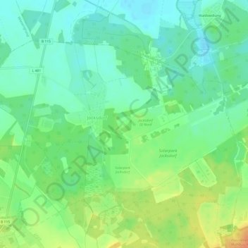
Name: Jocksdorf topographic map, elevation, terrain.
Average elevation: 99 m
Minimum elevation: 84 m
Maximum elevation: 123 m
Thank you for supporting this site ❤️
Make a donation
Make a donation
Other topographic maps
Click on a map to view its topography, its elevation and its terrain.
Zelz
Deutschland > Brandenburg > Spree-Neiße > Neiße-Malxetal
Historisch gehörte das Rittergut Zelz als Vasallengut zur Herrschaft Pförten. Als Folge des Wiener Kongresses wurde Zelz aus dem Königreich Sachsen in das Königreich Preußen umgegliedert, wo die Gemeinde im Landkreis Sorau im Regierungsbezirk Frankfurt in der Provinz Brandenburg lag. Im Jahr 1826…
Average elevation: 115 m