
Make a donation
Canberra topographic map
Click on the map to display elevation.
Make a donation
Canberra
The area chosen for the capital had been inhabited by Aboriginal Australians for up to 21,000 years, by groups including the Ngunnawal, Ngunawal and Ngambri. European settlement commenced in the first half of the 19th century, as evidenced by surviving landmarks such as St John's Anglican Church and Blundells Cottage. On 1 January 1901, federation of the colonies of Australia was achieved. Following a long dispute over whether Sydney or Melbourne should be the national capital, a compromise was reached: the new capital would be built in New South Wales, so long as it was at least 100 mi (160 km) from Sydney. The capital city was founded and formally named as Canberra in 1913. A plan by the American architects Walter Burley Griffin and Marion Mahony Griffin was selected after an international design contest, and construction commenced in 1913. Unusual among Australian cities, it is an entirely planned city. The Griffins' plan featured geometric motifs and was centred on axes aligned with significant topographical landmarks such as Black Mountain, Mount Ainslie, Capital Hill and City Hill. Canberra's mountainous location makes it the only mainland Australian city where snow-capped mountains can be seen in winter, although snow in the city itself is uncommon.
Make a donation
About this map
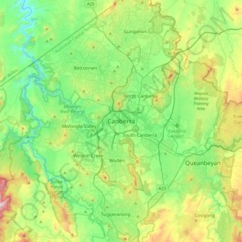
Name: Canberra topographic map, elevation, terrain.
Average elevation: 638 m
Minimum elevation: 395 m
Maximum elevation: 1,238 m
Make a donation
Other topographic maps
Click on a map to view its topography, its elevation and its terrain.
Make a donation
Make a donation
Make a donation
Melbourne
Melbourne is also prone to isolated convective showers forming when a cold pool crosses the state, especially if there is considerable daytime heating. These showers are often heavy and can include hail, squalls, and significant drops in temperature, but they often pass through very quickly with a rapid…
Average elevation: 185 m
Make a donation
Make a donation
Brisbane City
Brisbane's topography is characterized by a series of hills and ranges that define its landscape. The city is situated on a low-lying floodplain, with the Brisbane River meandering through its heart, creating a winding course with many steep curves from the southwest to its mouth at Moreton Bay in the east.…
Average elevation: 71 m
Make a donation