
Make a donation
Awka North topographic map
Click on the map to display elevation.
Make a donation
About this map
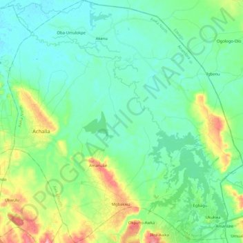
Name: Awka North topographic map, elevation, terrain.
Location: Awka North, Anambra State, Nigeria (6.23819 6.96108 6.44420 7.16220)
Average elevation: 47 m
Minimum elevation: 16 m
Maximum elevation: 139 m
Make a donation
Other topographic maps
Click on a map to view its topography, its elevation and its terrain.
Make a donation
Make a donation
Awka
Nigeria > Anambra State > Awka South
Awka lies below 300 metres above sea in a valley on the plains of the Mamu River. Two ridges or cuestas, both lying in a north–south direction, form the major topographical features of the area. The ridges reach the highest point at Agulu just outside the Capital Territory. About six kilometers east of this,…
Average elevation: 90 m
Make a donation
Make a donation