
Make a donation
Lake Maggiore topographic map
Click on the map to display elevation.
Make a donation
Lake Maggiore
Lake Maggiore weather is humid subtropical (Cfa in the Köppen climate classification). During winter, the lake helps to maintain a higher temperature in the surrounding region (since water releases heat energy more slowly than air). The temperatures are cooled down in summer by the breezes that blow on the water's surface, changing its colour. The area enjoys nearly 2300 hours of sunshine a year and an average annual temperature of 15.5 °C (60 °F). The water of the lake has a comfortable temperature of 20 to 22 °C (68 to 72 °F) in July and August. In winter snowfall is erratic and primarily affects the higher elevations. Rainfall is heaviest in May and lowest during the winter months.
Make a donation
About this map
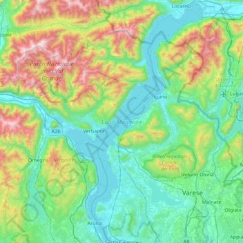
Name: Lake Maggiore topographic map, elevation, terrain.
Location: Lake Maggiore, Verbano-Cusio-Ossola, Piedmont, Italy (45.72243 8.48056 46.17992 8.86571)
Average elevation: 655 m
Minimum elevation: 184 m
Maximum elevation: 2,257 m
Make a donation
Other topographic maps
Click on a map to view its topography, its elevation and its terrain.
Mottarone
Italy > Piedmont > Verbano-Cusio-Ossola > Stresa
Mottarone is a mountain in the Western Alps of Piedmont, north-western Italy, with an elevation of 1,492 metres (4,895 ft). It is located between the provinces of Verbano-Cusio-Ossola and Novara.
Average elevation: 1,177 m
Make a donation
Make a donation
Make a donation
Giardini Botanici Villa Taranto
Italy > Piedmont > Verbano-Cusio-Ossola > Verbania
Average elevation: 210 m
Make a donation