
Make a donation
Ob River topographic map
Click on the map to display elevation.
Make a donation
Ob River
The combined Ob-Irtysh system, the fourth-longest river system of Asia (after Yenisei, and China's Yangzi and Yellow rivers), is 5,410 kilometres (3,360 mi) long, and the area of its basin 2,990,000 square kilometres (1,150,000 sq mi). The river basin of the Ob consists mostly of steppe, taiga, swamps, tundra, and semi-desert topography. The floodplains of the Ob are characterised by many tributaries and lakes. The Ob is icebound at southern Barnaul from early in November to near the end of April, and at northern Salekhard, 150 km (93 mi) above its mouth, from the end of October to the beginning of June. The Ob River crosses several climatic zones. The upper Ob valley, in the south, supports grapes, melons and watermelons, whereas the lower reaches of the Ob are Arctic tundra. The most temperate climates on the Ob are at Biysk, Barnaul, and Novosibirsk.
Make a donation
About this map
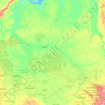
Name: Ob River topographic map, elevation, terrain.
Location: Ob River, Ural Federal District, Russia (52.30043 65.04695 66.78650 84.97333)
Average elevation: 122 m
Minimum elevation: -1 m
Maximum elevation: 1,948 m
Make a donation
Other topographic maps
Click on a map to view its topography, its elevation and its terrain.
Oymyakon
Russia > Sakha Republic > Oymyakonsky Ulus
With an extreme subarctic climate (Köppen climate classification Dfd, Trewartha climate classification Ecle), Oymyakon is known as one of the places considered the Northern Pole of Cold, the other being the town of Verkhoyansk, located 629 km (391 mi) away by air. The weather station is in a valley between…
Average elevation: 679 m
Kamensk-Uralsky
Russia > Sverdlovsk Oblast > городской округ Каменск-Уральский > Kamensk-Uralsky
Average elevation: 173 m
Yekaterinburg
Russia > Sverdlovsk Oblast > Yekaterinburg Municipality > Yekaterinburg
Average elevation: 274 m
Make a donation
Make a donation