
F/S Ward topographic map
Interactive map
Click on the map to display elevation.
About this map
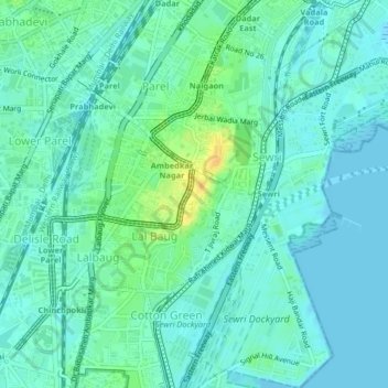
Name: F/S Ward topographic map, elevation, terrain.
Location: F/S Ward, Zone 2, Mumbai, Mumbai City, Maharashtra, India (18.97837 72.83302 19.01697 72.86979)
Average elevation: 8 m
Minimum elevation: -1 m
Maximum elevation: 29 m
Other topographic maps
Click on a map to view its topography, its elevation and its terrain.
Mumbai
India > Maharashtra > Mumbai
Mumbai is on a narrow peninsula on the southwest of Salsette Island, which lies between the Arabian Sea to the west, Thane Creek to the east and Vasai Creek to the north. Mumbai's suburban district occupies most of the island. Navi Mumbai is east of Thane Creek and Thane is north of Vasai Creek. Mumbai…
Average elevation: 19 m