
Headington Hill Park topographic map
Interactive map
Click on the map to display elevation.
About this map
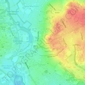
Name: Headington Hill Park topographic map, elevation, terrain.
Average elevation: 74 m
Minimum elevation: 50 m
Maximum elevation: 111 m
Other topographic maps
Click on a map to view its topography, its elevation and its terrain.
Binsey
United Kingdom > England > Oxford > Binsey
Binsey, Oxford, Oxfordshire, South East England, England, OX2 0NG, United Kingdom
Average elevation: 69 m
Blackbird Leys
United Kingdom > England > Oxford
Blackbird Leys, Oxford, Oxfordshire, South East, England, United Kingdom
Average elevation: 68 m
Angel and Greyhound Meadow
United Kingdom > England > Oxford
Angel and Greyhound Meadow, New Marston, Oxford, Oxfordshire, South East, England, United Kingdom
Average elevation: 68 m
Godstow
United Kingdom > England > Oxford > Godstow
Godstow, Oxford, Oxfordshire, South East, England, OX2 8PN, United Kingdom
Average elevation: 71 m
Hinksey Stream
United Kingdom > England > Oxford
Hinksey Stream, Oxford, Oxfordshire, South East, England, OX1 4SY, United Kingdom
Average elevation: 65 m
Bury Knowle Park
United Kingdom > England > Oxford
Bury Knowle Park, Headington, Oxford, Oxfordshire, South East, England, United Kingdom
Average elevation: 94 m
Risinghurst and Sandhills
United Kingdom > England > Oxford
Risinghurst and Sandhills, Oxford, Oxfordshire, South East, England, United Kingdom
Average elevation: 107 m
Castle Mill Stream
United Kingdom > England > Oxford
Castle Mill Stream, Oxford, Oxfordshire, South East, England, OX1 1HF, United Kingdom
Average elevation: 61 m