
Thank you for supporting this site ❤️
Make a donation
Make a donation
Maharagama topographic map
Click on the map to display elevation.
Thank you for supporting this site ❤️
Make a donation
Make a donation
About this map
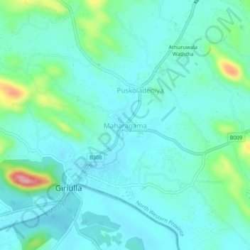
Name: Maharagama topographic map, elevation, terrain.
Average elevation: 61 m
Minimum elevation: 32 m
Maximum elevation: 183 m
Thank you for supporting this site ❤️
Make a donation
Make a donation
Other topographic maps
Click on a map to view its topography, its elevation and its terrain.
Beautiful strange rock formations
Sri Lanka > North Western Province > Kudiramale
Average elevation: 4 m
Thank you for supporting this site ❤️
Make a donation
Make a donation
Wembu Wewa
Sri Lanka > North Western Province > Ihala Puliyankulama > Weheragala
Average elevation: 55 m
Thank you for supporting this site ❤️
Make a donation
Make a donation