
Make a donation
Thailisain topographic map
Click on the map to display elevation.
Make a donation
About this map
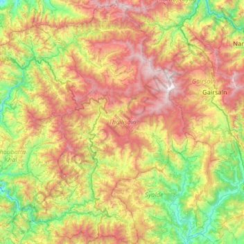
Name: Thailisain topographic map, elevation, terrain.
Location: Thailisain, Pauri Garhwal, Uttarakhand, India (29.76985 78.90707 30.22046 79.23187)
Average elevation: 1,704 m
Minimum elevation: 789 m
Maximum elevation: 3,066 m
Make a donation
Other topographic maps
Click on a map to view its topography, its elevation and its terrain.
Rishikesh
India > Uttarakhand > Rishikesh
Rishikesh is at 30°06′12″N 78°17′41″E / 30.103368°N 78.294754°E / 30.103368; 78.294754. It has an average elevation of 372 metres (1,220 ft). The town is located in the Tehri Garhwal region of the northern Indian state of Uttarakhand.
Average elevation: 497 m
Nainital
India > Uttarakhand > Nainital
The city of Nainital covers a total area of 11.73 km2 (4.53 sq mi), and is located at 29°23′N 79°27′E / 29.38°N 79.45°E / 29.38; 79.45, at an average elevation of 2,084 metres (6,837 ft) above sea level. The slopes of the nearby mountains are most populated, with an elevation ranging from…
Average elevation: 1,813 m
Make a donation
Haldwani
India > Uttarakhand > Haldwani
Haldwani is located at 29°13′N 79°31′E / 29.22°N 79.52°E / 29.22; 79.52, in the Nainital district on the right bank of the Gaula River. Geologically, Haldwani is settled on a piedmont grade (called Bhabhar) where the mountain rivers go underground to re-emerge in the Indo-Gangetic plain. The…
Average elevation: 673 m
Almora
India > Uttarakhand > Almora
Almora is located at 29°35′50″N 79°39′33″E / 29.5971°N 79.6591°E / 29.5971; 79.6591 in Almora district in Uttarakhand. Almora is situated 365 km north-east the national capital New Delhi and 415 km south-east the state capital Dehradun. It lies in the revenue Division Kumaon and is located…
Average elevation: 1,557 m
Make a donation
Make a donation
Make a donation
Make a donation
Make a donation
Uttarkashi
India > Uttarakhand > Bhatwari
It is the district headquarters of Uttarkashi district. Uttarkashi is situated on the banks of river Bhagirathi at an altitude of 1158 m above sea level. Uttarkashi is generally known as a holy town close to Rishikesh. It is located in the state of Uttarakhand in India. Uttarkashi is home to a number of…
Average elevation: 1,619 m
Make a donation
Make a donation
Make a donation
Make a donation
Make a donation
Make a donation
Make a donation
Make a donation
Bhowali
India > Uttarakhand > Nainital
Bhowali (Kumaoni: Bhoāli) is a town and a municipal board in Nainital District in the state of Uttarakhand, India. It is situated at a distance of 11 km (6.8 mi) from the city of Nainital, the district headquarters; at an average elevation of 1,654 m (5,427 ft) from sea level. It is the seat of Bhowali…
Average elevation: 1,672 m
Make a donation
Kathgodam
India > Uttarakhand > Haldwani
Kathgodam is located at 29°16′N 79°32′E / 29.27°N 79.53°E / 29.27; 79.53. It has an average elevation of 554 metres (1,483 feet). It is situated on the banks of the Gaula river.
Average elevation: 760 m
Make a donation
Make a donation
Make a donation
Tanakpur
India > Uttarakhand > Purnagiri
Tanakpur is located at 29°05′N 80°07′E / 29.08°N 80.12°E / 29.08; 80.12. It has an average elevation of 255 metres (837 feet).
Average elevation: 270 m
Make a donation
Gopeshwar
India > Uttarakhand > Chamoli Tehsil
Gopeshwar is located at 30°25′N 79°20′E / 30.42°N 79.33°E / 30.42; 79.33. It has an average elevation of 1,450 m (4,760 ft). Gopeshwar is 8.4 km (5.2 mi) away from Chamoli which is located on the banks of Alaknanda river and along NH 58. Gopeshwar is able to captivate any visitor with its…
Average elevation: 1,566 m
Make a donation
Make a donation
Make a donation
Make a donation
Make a donation
Make a donation