
Thank you for supporting this site ❤️
Make a donation
Make a donation
Épalinges topographic map
Click on the map to display elevation.
Thank you for supporting this site ❤️
Make a donation
Make a donation
About this map
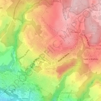
Name: Épalinges topographic map, elevation, terrain.
Location: Épalinges, District de Lausanne, Vaud, Switzerland (46.53798 6.64681 46.56680 6.68666)
Average elevation: 790 m
Minimum elevation: 658 m
Maximum elevation: 875 m
Thank you for supporting this site ❤️
Make a donation
Make a donation
Other topographic maps
Click on a map to view its topography, its elevation and its terrain.
Lausanne
Switzerland > Vaud > District de Lausanne > Lausanne
The most important geographical feature of the area surrounding Lausanne is Lake Geneva (Lac Léman in French). Lausanne is built on the southern slope of the Swiss plateau, with a difference in elevation of about 500 metres (1,640 ft) between the lakeshore at Ouchy and its northern edge bordering Le…
Average elevation: 577 m