
Thank you for supporting this site ❤️
Make a donation
Make a donation
Tzintzuntzan topographic map
Click on the map to display elevation.
Thank you for supporting this site ❤️
Make a donation
Make a donation
About this map
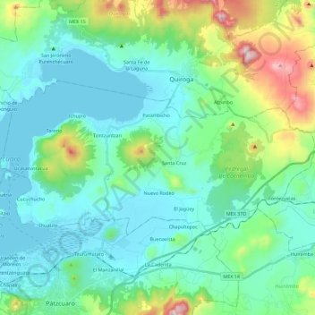
Name: Tzintzuntzan topographic map, elevation, terrain.
Location: Tzintzuntzan, Michoacán, 58440, Mexico (19.55917 -101.65280 19.66251 -101.42938)
Average elevation: 2,201 m
Minimum elevation: 2,034 m
Maximum elevation: 2,849 m
Thank you for supporting this site ❤️
Make a donation
Make a donation
Other topographic maps
Click on a map to view its topography, its elevation and its terrain.
Thank you for supporting this site ❤️
Make a donation
Make a donation
Ihuatzio
Mexico > Michoacán > Tzintzuntzan
Ihuatzio is located on the southeast of the Lake Pátzcuaro, about 8 kilometers southwest of the town center of Tzintzuntzan. Its average elevation is 2,052 meters above the sea level.
Average elevation: 2,052 m
Thank you for supporting this site ❤️
Make a donation
Make a donation