
Thank you for supporting this site ❤️
Make a donation
Make a donation
La Gatine topographic map
Click on the map to display elevation.
Thank you for supporting this site ❤️
Make a donation
Make a donation
About this map
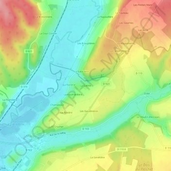
Name: La Gatine topographic map, elevation, terrain.
Average elevation: 151 m
Minimum elevation: 103 m
Maximum elevation: 219 m
Thank you for supporting this site ❤️
Make a donation
Make a donation
Other topographic maps
Click on a map to view its topography, its elevation and its terrain.
Plan d'eau de la Borde
France > Centre-Val de Loire > Eure-et-Loir > Arcisses > La Borde
Average elevation: 131 m