
Beltrami County topographic map
Interactive map
Click on the map to display elevation.
About this map
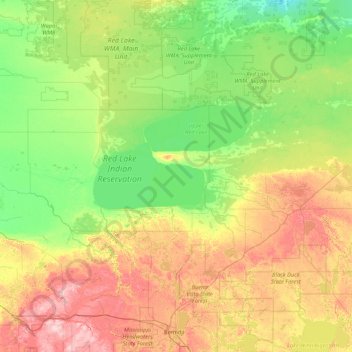
Name: Beltrami County topographic map, elevation, terrain.
Location: Beltrami County, Minnesota, USA (47.41027 -95.60268 48.54234 -94.41596)
Average elevation: 386 m
Minimum elevation: 338 m
Maximum elevation: 496 m
Other topographic maps
Click on a map to view its topography, its elevation and its terrain.
Alexandria
USA > Minnesota > Alexandria
Alexandria, Douglas County, Minnesota, 56308, USA
Average elevation: 426 m
Hula Lake
USA > Minnesota > Silver Rapids
Hula Lake, Fernberg Trl; Fernberg Rd, Silver Rapids, Lake County, Minnesota, USA
Average elevation: 411 m
Kettle River
Kettle River, Carlton County, Minnesota, 55757, USA
Average elevation: 367 m
Lake of the Woods County
Lake of the Woods County, Minnesota, USA
Average elevation: 343 m
Wenonah
USA > Minnesota > Minneapolis
Wenonah, Minneapolis, Hennepin County, Minnesota, USA
Average elevation: 255 m
Keller Lake
Keller Lake, North Maplewood Drive, Maplewood, Ramsey County, Minnesota, 55109, USA
Average elevation: 272 m