
Kings County topographic map
Interactive map
Click on the map to display elevation.
About this map
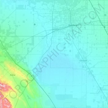
Name: Kings County topographic map, elevation, terrain.
Location: Kings County, California, United States of America (35.78861 -120.31511 36.48883 -119.47438)
Average elevation: 101 m
Minimum elevation: 53 m
Maximum elevation: 828 m
Table Mountain is the highest point in Kings County at an elevation of 3,476 feet (1,059 m). It is located in the Diablo Range in southwestern Kings County on the boundary between Kings and Monterey counties.
Other topographic maps
Click on a map to view its topography, its elevation and its terrain.
Big Bend
United States of America > California > Big Bend
Big Bend, Rock Springs Road, Big Bend, Shasta County, California, 96011, United States of America
Average elevation: 667 m
Santa Clara County
United States of America > California
Santa Clara County, California, United States of America
Average elevation: 323 m
Pasadena
United States of America > California > Pasadena
Pasadena, Los Angeles County, California, United States of America
Average elevation: 549 m
Santa Ana
United States of America > California > Santa Ana
Santa Ana, Orange County, California, United States of America
Average elevation: 30 m