Lomami topographic map
Interactive map
Click on the map to display elevation.
About this map
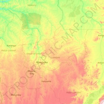
Name: Lomami topographic map, elevation, terrain.
Location: Lomami, Democratic Republic of the Congo (-8.72866 21.85780 -3.52866 27.05780)
Average elevation: 712 m
Minimum elevation: 374 m
Maximum elevation: 1,824 m
Other topographic maps
Click on a map to view its topography, its elevation and its terrain.
Maeba
Democratic Republic of the Congo > North Kivu > Lubero
Maeba, Baswaga, Lubero, North Kivu, Democratic Republic of the Congo
Average elevation: 1,165 m
Avu
Democratic Republic of the Congo > Ituri > Mahagi
Avu, Mahagi, Ituri, Democratic Republic of the Congo
Average elevation: 1,744 m
Burutu
Democratic Republic of the Congo > Sud-Ubangi
Burutu, Sud-Ubangi, Democratic Republic of the Congo
Average elevation: 407 m
Moba
Democratic Republic of the Congo > Tanganyika
Moba, Tanganyika, Democratic Republic of the Congo
Average elevation: 875 m
Oye
Democratic Republic of the Congo > Maniema > Kibombo
Oye, Kibombo, Maniema, Democratic Republic of the Congo
Average elevation: 532 m
Bandundu
Democratic Republic of the Congo
Bandundu, Democratic Republic of the Congo
Average elevation: 555 m
Katanga
Democratic Republic of the Congo
Katanga, Democratic Republic of the Congo
Average elevation: 1,008 m
Mai-Ndombe
Democratic Republic of the Congo
Mai-Ndombe, Democratic Republic of the Congo
Average elevation: 358 m
Nord-Ubangi
Democratic Republic of the Congo
Nord-Ubangi, Democratic Republic of the Congo
Average elevation: 471 m
Lower Uele
Democratic Republic of the Congo
Lower Uele, Democratic Republic of the Congo
Average elevation: 528 m
Kinshasa
Democratic Republic of the Congo > Kinshasa
Kinshasa, Democratic Republic of the Congo
Average elevation: 513 m
Kasai-Oriental
Democratic Republic of the Congo
Kasai-Oriental, Democratic Republic of the Congo
Average elevation: 713 m
Kwango
Democratic Republic of the Congo
Kwango, Democratic Republic of the Congo
Average elevation: 587 m
Sud-Ubangi
Democratic Republic of the Congo
Sud-Ubangi, Democratic Republic of the Congo
Average elevation: 421 m
Tshopo
Democratic Republic of the Congo > Tshopo
Tshopo, Democratic Republic of the Congo
Average elevation: 514 m
North Kivu
Democratic Republic of the Congo > North Kivu
North Kivu, Democratic Republic of the Congo
Average elevation: 1,069 m
Sankuru
Democratic Republic of the Congo > Sankuru
Sankuru, Democratic Republic of the Congo
Average elevation: 513 m
Ituri
Democratic Republic of the Congo > Ituri
Ituri, Democratic Republic of the Congo
Average elevation: 952 m
Yangambi
Democratic Republic of the Congo > Tshopo > Yangambi
Yangambi, Orientale, Tshopo, Democratic Republic of the Congo
Average elevation: 409 m
Lake Tanganyika
Democratic Republic of the Congo
Lake Tanganyika, Democratic Republic of the Congo
Average elevation: 1,064 m
Mont Amba
Democratic Republic of the Congo > Kinshasa
Mont Amba, Kinshasa, Democratic Republic of the Congo
Average elevation: 359 m
Haut-Katanga
Democratic Republic of the Congo > Haut-Katanga
Haut-Katanga, Democratic Republic of the Congo
Average elevation: 1,174 m