
Thank you for supporting this site ❤️
Make a donation
Make a donation
Bandundu topographic map
Click on the map to display elevation.
Thank you for supporting this site ❤️
Make a donation
Make a donation
About this map
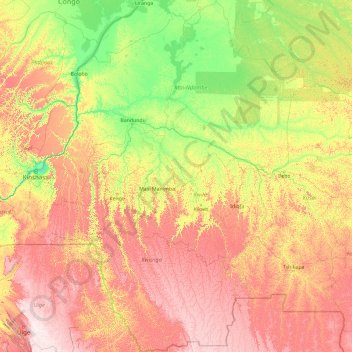
Name: Bandundu topographic map, elevation, terrain.
Location: Bandundu, Democratic Republic of the Congo (-8.13104 15.89472 -0.69543 21.00530)
Average elevation: 555 m
Minimum elevation: 256 m
Maximum elevation: 1,325 m
Thank you for supporting this site ❤️
Make a donation
Make a donation
Other topographic maps
Click on a map to view its topography, its elevation and its terrain.
Moba
Democratic Republic of the Congo > Tanganyika
Moba lies just south of the Mulobozi river. The Marungu highlands, a range of steep rugged hills, rises behind the town, bisected by the Mulobozi. The smaller northern section rises to an elevation of about 2,100 metres (6,900 ft) and the larger southern section to about 2,460 metres (8,070 ft). The highest…
Average elevation: 875 m
Thank you for supporting this site ❤️
Make a donation
Make a donation