
Delhi topographic map
Click on the map to display elevation.
Delhi
The topography of the medieval fort Purana Qila on the banks of the river Yamuna matches the literary description of the citadel Indraprastha in the Sanskrit epic Mahabharata; however, excavations in the area have revealed no signs of an ancient built environment. From the early 13th century until the mid-19th century, Delhi was the capital of two major empires, the Delhi Sultanate and the Mughal Empire, which covered large parts of South Asia. All three UNESCO World Heritage Sites in the city, the Qutub Minar, Humayun's Tomb, and the Red Fort, belong to this period. Delhi was the early centre of Sufism and Qawwali music. The names of Nizamuddin Auliya and Amir Khusrau are prominently associated with it. The Khariboli dialect of Delhi was part of a linguistic development that gave rise to the literature of Urdu and later Modern Standard Hindi. Major Urdu poets from Delhi include Mir Taqi Mir and Mirza Ghalib. Delhi was a notable centre of the Indian Rebellion of 1857. In 1911, New Delhi, a southern region within Delhi, became the capital of the British Indian Empire. During the Partition of India in 1947, Delhi was transformed from a Mughal city to a Punjabi one, losing two-thirds of its Muslim residents, in part due to the pressure brought to bear by the arriving Hindu and Sikh refugees from western Punjab. After independence in 1947, New Delhi continued as the capital of the Dominion of India, and after 1950, of the Republic of India.
About this map
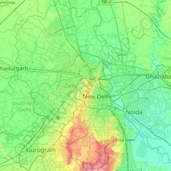
Name: Delhi topographic map, elevation, terrain.
Location: Delhi, India (28.40463 76.83884 28.88345 77.34525)
Average elevation: 218 m
Minimum elevation: 192 m
Maximum elevation: 315 m
Other topographic maps
Click on a map to view its topography, its elevation and its terrain.
Maharashtra
Maharashtra is the third largest state by area in India. The Western Ghats better known as Sahyadri, are a hilly range running parallel to the coast, at an average elevation of 1,200 metres (4,000 ft). Kalsubai, a peak in the Sahyadris, near Nashik city is the highest elevated point in Maharashtra. To the west…
Average elevation: 478 m
Mysuru
India > Karnataka > Mysuru taluk
Mysore (/maɪˈsɔːr/ (listen)), officially Mysuru ([ˈmaɪˈsuːɾu] (listen)), is a city in the southern part of the state of Karnataka, India. Mysore city is geographically located between 12° 18′ 26″ north latitude and 76° 38′ 59″ east longitude. It is located at an altitude of 770 m (2,530 ft)…
Average elevation: 727 m
Vadodara
India > Gujarat > Vadodara Rural Taluka
Vadodara is located at 22°18′N 73°11′E / 22.30°N 73.19°E / 22.30; 73.19 in western India at an elevation of 39 metres (128 ft). It is the tenth-largest city in India with an area of 400 square kilometres (150 sq mi) and a population of 3.5 million, according to the 2010–11 census. The city…
Average elevation: 36 m
Chennai
Chennai is located on the south–eastern coast of India in the north–eastern part of Tamil Nadu on a flat coastal plain known as the Eastern Coastal Plains. Its average elevation is around 6.7 metres (22 ft), and its highest point is 60 m (200 ft). Chennai is 2,184 kilometres (1,357 mi) south of Delhi,…
Average elevation: 7 m
Ranchi
Ranchi lies at 23°22′N 85°20′E / 23.36°N 85.33°E / 23.36; 85.33 near to the Tropic of Cancer. The city covers an area of 175 km2 (68 sq mi) and its average elevation is 651 m above sea level. Ranchi is located in the southern part of the Chota Nagpur plateau, which is the eastern section of…
Average elevation: 648 m
Sudarshan Parbat
India > Uttarakhand > Bhatwari
Sudarshan Parbat is a mountain of the Garhwal Himalaya in Uttarakhand India.The elevation of Sudarshan Parbat is 6,529 metres (21,421 ft) and its prominence is 456 metres (1,496 ft). It is joint 87th highest located entirely within the Uttrakhand. Nanda Devi, is the highest mountain in this category. Sudarshan…
Average elevation: 5,792 m
Lava
India > West Bengal > Kalimpong - II
Lava (also known as Lava Bazar) is a town in the Kalimpong II CD block in the Kalimpong subdivision of the Kalimpong district in the Indian state of West Bengal. As it lies in the high altitude, so it is also visible from high altitude towns and villages of East Sikkim, high areas of Bhutan and also from…
Average elevation: 1,931 m
Neyveli
India > Tamil Nadu > Virudhachalam
Neyveli is located at 11°36′N 79°29′E / 11.60°N 79.48°E / 11.60; 79.48. It has an average elevation of 87 metres (285 ft). It is located along with the Chennai-Thanjavur National Highway. Neyveli was a planned township and is sub-divided into 'blocks'. There are 32 blocks with each block…
Average elevation: 23 m
Siliguri
India > West Bengal > Matigara block
Siliguri located at the foothills of the eastern Himalayas at a location of 26°43′N 88°26′E / 26.71°N 88.43°E / 26.71; 88.43. This city is spread over an area of 260 km2 within the Siliguri Corridor, also known as the Chicken's neck. The city is surrounded by dense forests towards north and…
Average elevation: 121 m
Dehradun
India > Uttarakhand > Dehradun
The city of Dehradun mainly lies in Doon Valley and is at a varying height from 410 m (1,350 ft) in Clement Town to above 700 m (2,300 ft) at Malsi which is 15 km (9.3 mi) from the city. However, the average elevation is 450 m (1,480 ft) above sea level. Malsi is the starting point of Lesser Himalayan Range…
Average elevation: 904 m
Cuttack
India > Odisha > Cuttack (M.Corp.) P.S
Cuttack is located at 20°31′23″N 085°47′17″E / 20.52306°N 85.78806°E / 20.52306; 85.78806 and has an average elevation of 36 metres (118 ft). The city is spread across an area of 192.5 km2 (74 sq mi). The city, being a Cuttack Municipal Corporation which consists of 59 wards. The city…
Average elevation: 34 m
Kakinada
India > Andhra Pradesh > Kakinada Urban
Kakinada is located at 16°56′N 82°13′E / 16.93°N 82.22°E / 16.93; 82.22, with the 82-degrees east longitude passing through the city. The city has an average elevation of 2 meters (6.6 feet), and several areas lie below sea level.
Average elevation: 7 m
Bhopal
India > Madhya Pradesh > Huzur Tahsil
Bhopal has an average elevation of 500 metres (1401 ft) and is located in the central part of India, just north of the upper limit of the Vindhya mountain ranges. Located on the Malwa plateau, it is higher than the north Indian plains and the land rises towards the Vindhya Range to the south. The city has…
Average elevation: 498 m
Madurai
India > Tamil Nadu > Madurai
Madurai is located at 9°56′N 78°07′E / 9.93°N 78.12°E / 9.93; 78.12. It has an average elevation of 101 metres. The city of Madurai lies on the flat and fertile plain of the river Vaigai, which runs in the northwest-southeast direction through the city, dividing it into two almost equal…
Average elevation: 138 m
Mumbai
Mumbai lies at the mouth of the Ulhas River on the western coast of India, in the coastal region known as the Konkan. It sits on Salsette Island (Sashti Island), which it partially shares with the Thane district. Mumbai is bounded by the Arabian Sea to the west. Many parts of the city lie just above sea level,…
Average elevation: 13 m
Western Ghats
The range starts near south of the Tapti river and runs approximately 1,600 km (990 mi) through the states of Gujarat, Maharashtra, Karnataka, Goa, Kerala and Tamil Nadu ending at Marunthuvazh Malai, Swamithope near the southern tip of India. These hills cover 160,000 km2 (62,000 sq mi) and form the catchment…
Average elevation: 2,225 m
Aluva
Aluva Railway Station (IR Code: AWY) is a grade-A railway station in Kerala, and is the third busiest railway station in Kochi after Ernakulam Junction railway station and Ernakulam Town railway station. All passenger and express trains bound to southern Kerala have a stop at it. People travelling from the…
Average elevation: 11 m
Udupi
India > Karnataka > Udupi taluku
Udupi has an elevation of 27 m (89 ft) above mean sea level. The climate in Udupi is hot in summers and pleasant in winter. During summers (from March to May) the temperature reaches up to 38 °C (100 °F) and in winters (from December to February) it is usually between 32 and 20 °C (90 and 68 °F). As it is…
Average elevation: 17 m
Ranchi
Ranchi lies at 23°22′N 85°20′E / 23.36°N 85.33°E / 23.36; 85.33 near to the Tropic of Cancer. The city covers an area of 175 km2 (68 sq mi) and its average elevation is 651 m above sea level. Ranchi is located in the southern part of the Chota Nagpur plateau, which is the eastern section of…
Average elevation: 648 m
Nainital
India > Uttarakhand > Nainital
The city of Nainital covers a total area of 11.73 km2 (4.53 sq mi), and is located at 29°23′N 79°27′E / 29.38°N 79.45°E / 29.38; 79.45, at an average elevation of 2,084 metres (6,837 ft) above sea level. The slopes of the nearby mountains are most populated, with an elevation ranging from…
Average elevation: 1,813 m
Yercaud
India > Tamil Nadu > Yercaud
Yercaud, also spelt Erkad, is a town and hill station in Salem District in Tamil Nadu, India. Located in Servarayan Hills in the Eastern Ghats, it is situated at an altitude of 1,515 m (4,970 ft).
Average elevation: 1,092 m
Tirunelveli
India > Tamil Nadu > Tirunelveli
Tirunelveli is located at 8°43′41.82″N 77°41′43.94″E / 8.7282833°N 77.6955389°E / 8.7282833; 77.6955389, and its average elevation is 47 metres (154 ft). It is located at the southernmost tip of the Deccan plateau. The Tamirabarani River divides the city into the Tirunelveli quarter and…
Average elevation: 48 m
Idamalayar Dam
The Idamalayar Dam is located on the Idamalayar River, a tributary of the Periyar River in Kerala. Edamalayar originates in the Anamala Hills at elevation of 2,520 metres (8,270 ft). The river is a perennial source draining a catchment area of 381 km2 (147 sq mi) with a topography of high relief. The catchment…
Average elevation: 257 m
Kolhapur
India > Maharashtra > Karvir
Kolhapur is an inland city located in south-west Maharashtra state, 373 km (232 mi) south of Mumbai and 228 km (142 mi) south of Pune, 615 km (382 mi) north-west of Bengaluru and 530 km (330 mi) west of Hyderabad. Within Maharashtra, Kolhapur's nearest cities and towns are Ichalkaranji 27 km (17 mi), Kodoli 35…
Average elevation: 592 m
Thrissur
Thrissur is the headquarters of Thrissur district, in the centre of the Indian state of Kerala. The city is 75 km north-east of Kochi, 133 km south-west of Coimbatore, 124 km south-east of Kozhikode and 151 km north of Changanacherry. The city is located in a hillock called Thekkinkadu Maidan which is the…
Average elevation: 36 m
Leh
Leh (/ˈlɛ/) (Ladakhi: གླེ) is the joint capital and largest city of Ladakh, a union territory of India. Leh, located in the Leh district, was also the historical capital of the Kingdom of Ladakh, the seat of which was in the Leh Palace, the former residence of the royal family of Ladakh, built in the…
Average elevation: 4,294 m
Mussoorie
India > Uttarakhand > Dehradun
Mussoorie is at an average altitude of 2,005 metres (6,578 ft). To the northeast are the Himalayan snow ranges, and to the south, the Doon Valley and Shiwalik ranges. The second highest point is the original Lal Tibba in Landour, with a height of over 2,275 m (7,464 ft). Mussoorie is popularly known as The…
Average elevation: 1,594 m
Pollachi
India > Tamil Nadu > Pollachi
Pollachi is located at 10°39′43″N 77°00′23″E / 10.662°N 77.0065°E / 10.662; 77.0065. It has an average elevation of 293 metres (961 ft). Aliyar river passes about 10 kilometres (6.2 mi) away from the town and the town receives rainfall from Southwest monsoon due to the presence of Palghat gap.
Average elevation: 289 m
Navi Mumbai
India > Maharashtra > Thane > Navi Mumbai
Navi Mumbai (Marathi pronunciation: , also known by its former name New Bombay), is a planned city off the west coast of the Indian state of Maharashtra in Konkan division. The city is divided into two parts, North Navi Mumbai and South Navi Mumbai, for the individual development of Panvel Mega City, which…
Average elevation: 30 m
Surat
India > Gujarat > Katargam Taluka > Surat
Surat is a port city situated on the banks of the Tapi river. Damming of the Tapi caused the original port facilities to close; the nearest port is now in the Magadalla and Hazira area of Surat Metropolitan Region.It has famous beach called 'Dumas Beach' located in Hazira. The city is located at 21°10′N…
Average elevation: 11 m