
Hanle topographic map
Click on the map to display elevation.
About this map
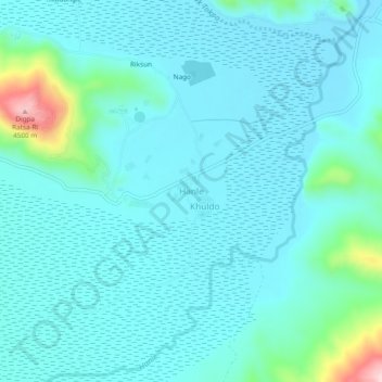
Name: Hanle topographic map, elevation, terrain.
Location: Hanle, Leh district, India (32.75148 78.96321 32.79148 79.00321)
Average elevation: 4,287 m
Minimum elevation: 4,249 m
Maximum elevation: 4,517 m
Other topographic maps
Click on a map to view its topography, its elevation and its terrain.
Bengaluru
India > Karnataka > Bangalore North
Bengaluru (formerly Bangalore) is situated in the southeastern part of Karnataka, India, within the Bengaluru Urban district. It lies at an elevation of approximately 900 meters (3,000 feet) above sea level, on the Deccan Plateau. This elevated position gives the city a moderate climate, with temperatures…
Average elevation: 881 m
Chennai
Chennai is located on the southeastern coast of India in the northeastern part of Tamil Nadu on a flat coastal plain known as the Eastern Coastal Plains with an average elevation of 6.7 m (22 ft) and highest point at 60 m (200 ft). Chennai's soil is mostly clay, shale and sandstone. Clay underlies most of the…
Average elevation: 8 m
Mumbai
India > Maharashtra > Mumbai
Mumbai is on a narrow peninsula on the southwest of Salsette Island, which lies between the Arabian Sea to the west, Thane Creek to the east and Vasai Creek to the north. Mumbai's suburban district occupies most of the island. Navi Mumbai is east of Thane Creek and Thane is north of Vasai Creek. Mumbai…
Average elevation: 18 m
Hyderabad
India > Telangana > Bahadurpura mandal
Hyderabad (/ˈhaɪdərəbæd/ HY-dər-ə-bad; Telugu: [ˈɦaɪ̯daraːbaːd], Urdu: [ˈɦɛːdəɾaːbaːd]) is the capital and largest city of the Indian state of Telangana. It occupies 650 km2 (250 sq mi) on the Deccan Plateau along the banks of the Musi River, in the northern part of Southern India. With an…
Average elevation: 549 m
Tamil Nadu
The annual rainfall of the state is about 945 mm (37.2 in) of which 48 per cent is through the northeast monsoon, and 32 per cent through the southwest monsoon. Since the state is entirely dependent on rains for recharging its water resources, monsoon failures lead to acute water scarcity and severe drought.…
Average elevation: 253 m
Haryana
Haryana is a landlocked state in northern India. It is between 27°39' to 30°35' N latitude and between 74°28' and 77°36' E longitude. The total geographical area of the state is 4.42 m ha, which is 1.4% of the geographical area of the country. The altitude of Haryana varies between 700 and 3600 ft (200…
Average elevation: 281 m
Chennai
Chennai is located on the southeastern coast of India in the northeastern part of Tamil Nadu on a flat coastal plain known as the Eastern Coastal Plains with an average elevation of 6.7 m (22 ft) and highest point at 60 m (200 ft). Chennai's soil is mostly clay, shale and sandstone. Clay underlies most of the…
Average elevation: 8 m
Kerala
Kerala was alternatively called Malabar in the foreign trade circles. Earlier, the term Malabar had also been used to denote Tulu Nadu and Kanyakumari which lie contiguous to Kerala on the southwestern coast of India, in addition to the modern state of Kerala. The people of Malabar were known as Malabars.…
Average elevation: 251 m
Maharashtra
Maharashtra with a total area of 307,713 km2 (118,809 sq mi), is the third-largest state by area in terms of land area and constitutes 9.36 per cent of India's total geographical area. The State lies between 15°35' N to 22°02' N latitude and 72°36' E to 80°54' E longitude. It occupies the western and…
Average elevation: 346 m
Uttar Pradesh
Uttar Pradesh, with a total area of 243,290 square kilometres (93,935 sq mi), is India's fourth-largest state in terms of land area and is roughly of same size as United Kingdom. It is situated on the northern spout of India and shares an international boundary with Nepal. The Himalayas border the state on the…
Average elevation: 954 m
Jalna District
The district occupies an area of 7,718 square kilometres (2,980 sq mi). The range of geographical latitudes and longitudes of the district is from 19.01' N to 21.03'N and from 75.04'E to 76.04'E, with gently to moderately sloping topography. The Northern part of the district is occupied by the Ajanta and…
Average elevation: 542 m
Nagaland
Nagaland lies between 93°20'E and 95°15'E longitude and between 25°6'N and 27°4'N latitude. It is largely a mountainous state. The Naga Hills rise from the Brahmaputra Valley in Assam to about 610 metres (2,000 ft) and rise further to the southeast, as high as 1,800 metres (6,000 ft). Mount Saramati at an…
Average elevation: 824 m
Punjab
Punjab is in northwestern India and has a total area of 50,362 square kilometres (19,445 sq mi). Punjab is bordered by Pakistan's Punjab province on the west, Jammu and Kashmir on the north, Himachal Pradesh on the northeast and Haryana and Rajasthan on the south. Most of Punjab lies in a fertile, alluvial…
Average elevation: 477 m
Bengaluru
India > Karnataka > Bangalore North
Bengaluru (formerly Bangalore) is situated in the southeastern part of Karnataka, India, within the Bengaluru Urban district. It lies at an elevation of approximately 900 meters (3,000 feet) above sea level, on the Deccan Plateau. This elevated position gives the city a moderate climate, with temperatures…
Average elevation: 881 m
Pune City
Pune lies on the western margin of the Deccan plateau, at an altitude of 560 m (1,840 ft) above sea level. It is on the leeward side of the Sahyadri mountain range, which forms a barrier from the Arabian Sea. It is a hilly city, with Vetal Hill rising to 800 m (2,600 ft) above sea level. The Sinhagad fort is…
Average elevation: 616 m
Odisha
Three-quarters of the state is covered in mountain ranges. Deep and broad valleys have been made in them by rivers. These valleys have fertile soil and are densely populated. Odisha also has plateaus and rolling uplands, which have lower elevation than the plateaus. The highest point in the state is Deomali at…
Average elevation: 228 m
Idukki
Though it is the second-largest district in the region in terms of area, it has the lowest population density among the districts of Kerala. There are only two municipalities in the district and the urban population is comparatively much lower than the rural population, due to its mountainous nature. The 2,695…
Average elevation: 607 m
Karnataka
The bulk of the state is in the Bayaluseeme region, the northern part of which is the second-largest arid region in India. The highest point in Karnataka is the Mullayanagiri hills in Chikmagalur district which has an altitude of 1,925 metres (6,316 ft). The two main river systems of the state are the Krishna…
Average elevation: 386 m
Sikkim
Situated in the Himalayan mountains, the state of Sikkim is characterised by mountainous terrain. Almost the entire state is hilly, with an elevation ranging from 280 metres (920 ft) in the south at the border with West Bengal to 8,586 metres (28,169 ft) in northern peaks near Nepal and Tibet. The summit of…
Average elevation: 3,786 m
Goa
Goa is a part of the coastal country known as the Konkan, which is an escarpment rising up to the Western Ghats range of mountains, which separate it from the Deccan Plateau. The highest point is the Sonsogor Peak, with an altitude of 1,026 m (3,366 ft). Goa has a coastline of 160 km (99 mi).
Average elevation: 228 m
West Bengal
The distribution of vegetation in northern West Bengal is dictated by elevation and precipitation. For example, the foothills of the Himalayas, the Dooars, are densely wooded with sal and other tropical evergreen trees. Above an elevation of 1,000 metres (3,300 ft), the forest becomes predominantly…
Average elevation: 182 m
Malappuram
Bounded by Kozhikode district to the northwest, Wayanad district to the northeast, Nilgiri hills to the east, Palakkad district to the southeast, Thrissur district to the southwest, and Arabian Sea to the west, Malappuram has a total geographical area of 3,554 km2, which ranks third in the state in terms of…
Average elevation: 224 m
Tamil Nadu
The annual rainfall of the state is about 945 mm (37.2 in) of which 48 per cent is through the northeast monsoon, and 32 per cent through the southwest monsoon. Since the state is entirely dependent on rains for recharging its water resources, monsoon failures lead to acute water scarcity and severe drought.…
Average elevation: 253 m
Kerala
Kerala was alternatively called Malabar in the foreign trade circles. Earlier, the term Malabar had also been used to denote Tulu Nadu and Kanyakumari which lie contiguous to Kerala on the southwestern coast of India, in addition to the modern state of Kerala. The people of Malabar were known as Malabars.…
Average elevation: 251 m
Karnataka
The bulk of the state is in the Bayaluseeme region, the northern part of which is the second-largest arid region in India. The highest point in Karnataka is the Mullayanagiri hills in Chikmagalur district which has an altitude of 1,925 metres (6,316 ft). The two main river systems of the state are the Krishna…
Average elevation: 386 m
Nilgiris
The district has an area of 2,552.50 km2. The district is basically hilly, lying at an elevation of 1,000 to 2,600 metres above MSL, and divided between the Nilgiri plateau and the lower, smaller Wayanad plateau. The district lies at the juncture of the Western Ghats and the Eastern Ghats. Its latitudinal and…
Average elevation: 975 m
Betul
The mean elevation above the sea is about 2000 ft. The country is essentially a highland tract, divided naturally into three distinct portions, differing in their superficial aspects, the character of their soil and their geological formation. The northern part of the district forms an irregular plain of the…
Average elevation: 533 m
Madurai
India > Tamil Nadu > Madurai
Madurai is located at 9°56′N 78°07′E / 9.93°N 78.12°E / 9.93; 78.12. It has an average elevation of 101 metres. The city of Madurai lies on the flat and fertile plain of the river Vaigai, which runs in the northwest-southeast direction through the city, dividing it into two almost equal…
Average elevation: 138 m
Bihar
Bihar covers a total area of 94,163 km2 (36,357 sq mi), with an average elevation above sea level of 173 feet (53 m). It is land locked by Nepal in the north, Jharkhand in the south West Bengal in the east and Uttar Pradesh to the west. It has three parts on the basis of physical and structural conditions: the…
Average elevation: 605 m
Himachal Pradesh
Due to extreme variation in elevation, great variation occurs in the climatic conditions of Himachal. The climate varies from hot and humid subtropical in the southern tracts to, with more elevation, cold, alpine, and glacial in the northern and eastern mountain ranges. The state's winter capital, Dharamsala…
Average elevation: 2,869 m
Bihar
Bihar covers a total area of 94,163 km2 (36,357 sq mi), with an average elevation above sea level of 173 feet (53 m). It is land locked by Nepal in the north, Jharkhand in the south West Bengal in the east and Uttar Pradesh to the west. It has three parts on the basis of physical and structural conditions: the…
Average elevation: 605 m
Madhya Pradesh
Madhya Pradesh literally means "Central Province", and is located in the geographic heart of India in between the latitude of 21.6°N–26.30°N and longitude of 74°9'E–82°48'E. The state straddles the Narmada River, which runs east and west between the Vindhya and Satpura ranges; these ranges and the…
Average elevation: 347 m
Uttar Pradesh
Uttar Pradesh, with a total area of 240,928 square kilometres (93,023 sq mi), is India's fourth-largest state in terms of land area and is roughly of same size as United Kingdom. It is situated on the northern spout of India and shares an international boundary with Nepal. The Himalayas border the state on the…
Average elevation: 954 m
Mumbai
Mumbai is on a narrow peninsula on the southwest of Salsette Island, which lies between the Arabian Sea to the west, Thane Creek to the east and Vasai Creek to the north. Mumbai's suburban district occupies most of the island. Navi Mumbai is east of Thane Creek and Thane is north of Vasai Creek. Mumbai…
Average elevation: 18 m
Uttarakhand
Uttarakhand lies on the southern slope of the Himalaya range, and the climate and vegetation vary greatly with elevation, from glaciers at the highest elevations to subtropical forests at the lower elevations. The highest elevations are covered by ice and bare rock. Below them, between 3,000 and 5,000 metres…
Average elevation: 2,102 m
Kinnaur
Kinnaur is an entirely mountainous district. The general altitude range is 1,500 metres above sea level to over 6,000 metres above sea level. The district is drained by several tributaries of the Sutlej river. Three mountain ranges run through or touch Kinnaur: the Zanskar range, the Great Himalaya range, and…
Average elevation: 4,232 m
Banda
The hills of the district consist of the part of the Vindhyan plateau which lies in the extreme southern portion of the tahsils Mau and Karwi (now known as the district Chitrakut). The northern flank of the Vindhyas known as Vindhyachal range, starts near the Yamuna in the extreme east of tahsil Mau. It…
Average elevation: 137 m
Ludhiana District
The topography of the district is a typical representative of an alluvial plain. It owes its origin to the aggravation work of the Satluj River. The alluvium deposited by the river has been worked over by the wind, which gave rise to a number of small dunes and sand mounds. Most of these dunes have been…
Average elevation: 246 m
Sirohi
Sirohi District is broken up by hills and rocky ranges. The granite massif of Mount Abu divides the district into two portions, running from north-east to south-west. The south and south-east part of the district, which lies between Mount Abu and the main spine of the Aravallis, is mountainous and rugged, and…
Average elevation: 351 m
Haryana
Haryana is a landlocked state in northern India. It is between 27°39' to 30°35' N latitude and between 74°28' and 77°36' E longitude. The total geographical area of the state is 4.42 m ha, which is 1.4% of the geographical area of the country. The altitude of Haryana varies between 700 and 3600 ft (200…
Average elevation: 281 m
Pauri Garhwal
The mountains of Khirsu offer views of the northern Himalayas and attract a large number of tourists. Located 19 kilometres (12 mi) away from Pauri at an altitude of 1,700 metres (5,600 ft), Khirsu is peaceful and free from pollution. There is the nearby ancient temple of Ghandiyal Devta. Accommodation is…
Average elevation: 958 m
Wayanad
Wayanad (IPA: [ʋɐjɐnaːɖɨ̆]) is a district in the north-east of Indian state Kerala with administrative headquarters at the municipality of Kalpetta. It is the only plateau in Kerala. The Wayanad Plateau forms a continuation of the Mysore Plateau, the southern portion of Deccan Plateau. It is set high in…
Average elevation: 724 m
Rajasthan
The Aravalli Range runs across the state from the southwest peak Guru Shikhar (Mount Abu), which is 1,722 metres (5,650 ft) in height, to Khetri in the northeast. This range divides the state into 60% in the northwest of the range and 40% in the southeast. The northwest tract is sandy and unproductive with…
Average elevation: 254 m
Karnataka
The bulk of the state is in the Bayaluseeme region, the northern part of which is the second-largest arid region in India. The highest point in Karnataka is the Mullayanagiri hills in Chikmagalur district which has an altitude of 1,925 m (6,316 ft). The two main river systems of the state are the Krishna and…
Average elevation: 386 m
Uttarakhand
Uttarakhand lies on the southern slope of the Himalaya range, and the climate and vegetation vary greatly with elevation, from glaciers at the highest elevations to subtropical forests at the lower elevations. The highest elevations are covered by ice and bare rock. Below them, between 3,000 and 5,000 metres…
Average elevation: 2,107 m
Pune City Subdistrict
Pune is situated at approximately 18° 32" north latitude and 73° 51" east longitude. The area of Pune district is 15,642 km2, and the municipal corporation area covers 518 km2. By road Pune is 149 km (93 mi) south-east of Mumbai, 580 km (360 mi) south-west of Indore, 695 km (432 mi) west of Nagpur, 1,173 km…
Average elevation: 616 m
Arunachal Pradesh
The climate of Arunachal Pradesh varies with elevation. The low-altitude areas have a humid subtropical climate. High-altitude areas (3500–5500 m) have a subtropical highland climate and alpine climate. Arunachal Pradesh receives 2,000 to 5,000 millimetres (79 to 197 in) of rainfall annually, 70%–80%…
Average elevation: 2,429 m
Meghalaya
Meghalaya, alongside neighbouring Indian states, has been of archaeological interest. People have lived in Meghalaya since the Neolithic period. Neolithic sites discovered so far are located in areas of high elevation in Khasi Hills, Garo Hills and in neighbouring states, where Neolithic style jhum or shifting…
Average elevation: 244 m
Andhrapradesh Forest Departement Head Office , Jilledu Makivalasa
India > Andhra Pradesh > Narasannapeta > Tamarapalle
Average elevation: 37 m
Jaynagar Majilpur
India > West Bengal > Jaynagar - I
Jaynagar Majilpur is located at 22°10′31″N 88°25′12″E / 22.1751965°N 88.4200762°E / 22.1751965; 88.4200762. It has an average elevation of 8 metres (26 ft).
Average elevation: 5 m
Dakshina Kannada
The topography of the district is plain up to 30 km (18.64 mi) inside the coast and changes to undulating hilly terrain sharply towards the east in the Western Ghats. Teak, bamboo and rosewood trees are found in the hilly areas towards the east. The Geological Survey of India has identified this district as a…
Average elevation: 109 m
Kanniyakumari
Kanyakumari district has a varied topography with sea on three sides and the mountains of the Western Ghats bordering the northern side. Except for a small stretch of land to the west of Kanyakumari town, almost the entire district is sandwiched between the Western Ghats and the Arabian Sea - the only district…
Average elevation: 226 m
Punjab
Punjab is in northwestern India and has a total area of 50,362 square kilometres (19,445 sq mi). Punjab is bordered by Pakistan's Punjab province on the west, Jammu and Kashmir on the north, Himachal Pradesh on the northeast and Haryana and Rajasthan on the south. Most of Punjab lies in a fertile, alluvial…
Average elevation: 477 m
Maharashtra
Maharashtra with a total area of 307,713 km2 (118,809 sq mi), is the third-largest state by area in terms of land area and constitutes 9.36 per cent of India's total geographical area. The State lies between 15°35' N to 22°02' N latitude and 72°36' E to 80°54' E longitude. It occupies the western and…
Average elevation: 346 m
Mizoram
Mizoram is a land of rolling hills, valleys, rivers and lakes. As many as 21 major hill ranges or peaks of different heights run through the length and breadth of the state, with plains scattered here and there. The average height of the hills to the west of the state is about 1,000 metres (3,300 ft). These…
Average elevation: 544 m