
Thank you for supporting this site ❤️
Make a donation
Make a donation
Maud topographic map
Click on the map to display elevation.
Thank you for supporting this site ❤️
Make a donation
Make a donation
About this map
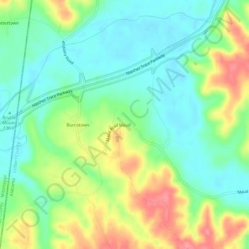
Name: Maud topographic map, elevation, terrain.
Location: Maud, Colbert County, Alabama, United States (34.62315 -88.12976 34.66315 -88.08976)
Average elevation: 158 m
Minimum elevation: 127 m
Maximum elevation: 212 m
Thank you for supporting this site ❤️
Make a donation
Make a donation
Other topographic maps
Click on a map to view its topography, its elevation and its terrain.