
Thank you for supporting this site ❤️
Make a donation
Make a donation
Littleville topographic map
Click on the map to display elevation.
Thank you for supporting this site ❤️
Make a donation
Make a donation
About this map
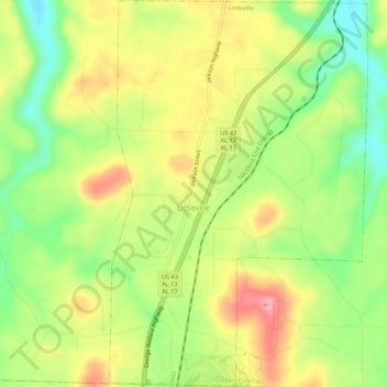
Name: Littleville topographic map, elevation, terrain.
Location: Littleville, Colbert County, Alabama, United States (34.56997 -87.68877 34.61450 -87.65255)
Average elevation: 210 m
Minimum elevation: 147 m
Maximum elevation: 277 m
Thank you for supporting this site ❤️
Make a donation
Make a donation
Other topographic maps
Click on a map to view its topography, its elevation and its terrain.
Hawk Pride Mountain
United States > Alabama > Colbert County
Hawk Pride Mountain is a summit in Colbert County, Alabama, in the United States. With an elevation of 820 feet (250 m), is the 489th highest summit in the state of Alabama.
Average elevation: 231 m
Thank you for supporting this site ❤️
Make a donation
Make a donation
Thank you for supporting this site ❤️
Make a donation
Make a donation
Thank you for supporting this site ❤️
Make a donation
Make a donation