
Thank you for supporting this site ❤️
Make a donation
Make a donation
Saratoga Lake topographic map
Click on the map to display elevation.
Thank you for supporting this site ❤️
Make a donation
Make a donation
About this map
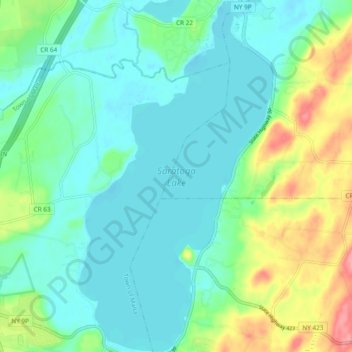
Name: Saratoga Lake topographic map, elevation, terrain.
Average elevation: 82 m
Minimum elevation: 58 m
Maximum elevation: 150 m
Thank you for supporting this site ❤️
Make a donation
Make a donation
Other topographic maps
Click on a map to view its topography, its elevation and its terrain.
Village of Round Lake
United States > New York > Saratoga County > Town of Malta
Average elevation: 62 m