Geolocate

Le Petit Cap topographic map

Click on the map to display elevation.

About this map

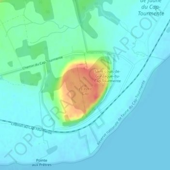
Name: Le Petit Cap topographic map, elevation, terrain.

Location: Le Petit Cap, La Côte-de-Beaupré, Capitale-Nationale, Quebec, G0A 3X0, Canada (47.06103 -70.80774 47.06113 -70.80764)

Average elevation: 11 m

Minimum elevation: -2 m

Maximum elevation: 55 m

Other topographic maps

Click on a map to view its topography, its elevation and its terrain.

Gatineau

Canada > Quebec

Gatineau is located in southwestern Quebec, on the northern bank of the Gatineau River. It is situated at an elevation of around 50 m (164.042 ft) The Gatineau Hills are the foothills of the Laurentian Mountains and located in the region. It is also the location of the second largest urban park in the world.…

Average elevation: 127 m

Quebec

Canada > Quebec > Urban agglomeration of Québec

Quebec City was built on the north bank of the Saint Lawrence River, where it narrows and meets the mouth of the Saint-Charles River. Old Quebec is located on top and at the foot of Cap-Diamant, which is on the eastern edge of a plateau called the promontory of Quebec (Quebec hill). Because of this topographic…

Average elevation: 117 m

Bromont

Canada > Quebec > Brome-Missisquoi

Average elevation: 192 m

Lac Brûlé

Canada > Quebec > Minganie > Lac-Jérôme

Average elevation: 516 m

Avignon

Canada > Quebec

Average elevation: 299 m

Laval (administrative region)

Canada > Quebec

Average elevation: 42 m

Quebec

Canada > Quebec > Urban agglomeration of Québec

Quebec City was built on the north bank of the Saint Lawrence River, where it narrows and meets the mouth of the Saint-Charles River. Old Quebec is located on top and at the foot of Cap-Diamant, which is on the eastern edge of a plateau called the promontory of Quebec (Quebec hill). Because of this topographic…

Average elevation: 117 m

Waltham

Canada > Quebec > Pontiac

Its territory, with a maximum elevation of just over 350 metres (1,150 ft), is sparsely populated, the majority of the population living along or near the Ottawa River. The northern portion is a vast extended tract of undeveloped land, dotted with lakes, such as Findlay, Landon, Gagnon, and Caughlin, which are…

Average elevation: 245 m

Vaudreuil-Dorion

Canada > Quebec > Vaudreuil-Soulanges

Average elevation: 37 m

Rouyn-Noranda

Canada > Quebec

Average elevation: 307 m

Blainville

Canada > Quebec > Thérèse-De Blainville

Average elevation: 66 m

Mont-Tremblant

Canada > Quebec > Les Laurentides

The city is dominated by Mont Tremblant with an altitude of 968m which is one of the highest peaks in southern Quebec.

Average elevation: 358 m

Lac Saint-Jean

Canada > Quebec > Lac-Saint-Jean-Est

Average elevation: 127 m

Sainte-Marthe

Canada > Quebec > Vaudreuil-Soulanges

Average elevation: 77 m

Côte-Nord

Canada > Quebec

Average elevation: 327 m

Sherbrooke

Canada > Quebec

Average elevation: 232 m

Repentigny

Canada > Quebec > L'Assomption (MRC)

Average elevation: 14 m

L'Île-Perrot

Canada > Quebec > Vaudreuil-Soulanges

Average elevation: 33 m

Saint-Sauveur

Canada > Quebec > Les Pays-d'en-Haut

Average elevation: 294 m

Roberval

Canada > Quebec > Le Domaine-du-Roy

Average elevation: 211 m

Morin-Heights

Canada > Quebec > Les Pays-d'en-Haut

Average elevation: 348 m

Laurentides

Canada > Quebec

Average elevation: 334 m

Rimouski

Canada > Quebec > Rimouski-Neigette

The tide station located at Pointe-au-Père serves as the reference point for measuring mean sea level for the North American Vertical Datum of 1988, which is the reference point for determining altitude in North America.

Average elevation: 126 m

Gaspé Peninsula

Canada > Quebec

Average elevation: 190 m

Hudson

Canada > Quebec > Vaudreuil-Soulanges

Average elevation: 56 m

Montérégie

Canada > Quebec

Average elevation: 157 m

Chibougamau

Canada > Quebec

Average elevation: 392 m

Saint-Norbert-d'Arthabaska

Canada > Quebec > Arthabaska

Average elevation: 237 m

Mirabel

Canada > Quebec

Average elevation: 71 m

Témiscamingue

Canada > Quebec

Average elevation: 318 m

Shawinigan

Canada > Quebec

Average elevation: 215 m

Vaudreuil-Soulanges

Canada > Quebec

Average elevation: 54 m

Chaleur Bay

Canada > Quebec

Average elevation: 102 m

Abitibi-Témiscamingue

Canada > Quebec

Average elevation: 333 m

Bas-Saint-Laurent

Canada > Quebec

The topography of Bas-Saint-Laurent has two main elements : the plateaus of the Appalachian Mountains, called Notre Dame Mountains, and the lowlands in the fine stripe of land along the Saint Lawrence river. These are separated by an intermediate area of ridges and foothills which meld with the plateaus. The…

Average elevation: 285 m

Capitale-Nationale

Canada > Quebec

Average elevation: 375 m

Chaudière-Appalaches

Canada > Quebec

Average elevation: 323 m

Nord-du-Québec

Canada > Quebec

Average elevation: 215 m

Outaouais

Canada > Quebec

Average elevation: 318 m

Rivière Saint-Maurice

Canada > Quebec

Average elevation: 391 m

Rivière Nottaway

Canada > Quebec

Average elevation: 219 m

Rivière Broadback

Canada > Quebec

Average elevation: 261 m

Rivière Arnaud

Canada > Quebec

Average elevation: 218 m

Kativik

Canada > Quebec

Average elevation: 168 m

Châteauguay

Canada > Quebec > Roussillon

Average elevation: 32 m

Lévis

Canada > Quebec

Average elevation: 96 m

Deux-Montagnes (MRC)

Canada > Quebec

Average elevation: 49 m

Magog

Canada > Quebec > Memphrémagog

Average elevation: 250 m

Manicouagan

Canada > Quebec

Average elevation: 437 m

Le Rocher-Percé

Canada > Quebec

Average elevation: 147 m

Cantley

Canada > Quebec > Les Collines-de-l'Outaouais

Average elevation: 185 m

Rawdon

Canada > Quebec > Matawinie

Average elevation: 197 m

Wakefield

Canada > Quebec > Les Collines-de-l'Outaouais

Average elevation: 151 m

La Grande Rivière

Canada > Quebec

Average elevation: 489 m

Brome-Missisquoi

Canada > Quebec

Average elevation: 182 m

Anticosti Island

Canada > Quebec

Topographically, Anticosti Island can be divided into three distinct regions: two lowland areas, rarely exceeding 150 metres (490 ft) in elevation, in the eastern and western thirds of the island linked along the coast; and a central highland forming a plateau that rises to just over 300 m (980 ft). This…

Average elevation: 30 m

Abitibi

Canada > Quebec

Average elevation: 314 m

Les Pays-d'en-Haut

Canada > Quebec

Average elevation: 334 m

Saguenay–Lac-Saint-Jean

Canada > Quebec

Average elevation: 449 m

Charlevoix

Canada > Quebec

Average elevation: 593 m

Beauharnois-Salaberry

Canada > Quebec

Average elevation: 44 m

Les Collines-de-l'Outaouais

Canada > Quebec

Average elevation: 177 m

Jamésie

Canada > Quebec

Average elevation: 344 m

Rouyn

Canada > Quebec

Average elevation: 297 m

Rivière Romaine

Canada > Quebec

Average elevation: 479 m

Canton de Cleveland

Canada > Quebec

Average elevation: 209 m

Coulonge River

Canada > Quebec

Average elevation: 318 m

Estrie

Canada > Quebec

Average elevation: 348 m

Lac Clair

Canada > Quebec

Average elevation: 338 m

Argenteuil

Canada > Quebec

Average elevation: 189 m

Papineau

Canada > Quebec

Average elevation: 232 m

Saguenay

Canada > Quebec

Average elevation: 268 m

Rivière Péribonka

Canada > Quebec

Average elevation: 487 m

Trois-Rivières

Canada > Quebec

Average elevation: 39 m

Ottawa River (North)

Canada > Quebec

Average elevation: 347 m

Centre-du-Québec

Canada > Quebec

Average elevation: 132 m

Mauricie

Canada > Quebec

Average elevation: 395 m

Lanaudière

Canada > Quebec

The region of Lanaudière is part of central Quebec and is located between the Saint Lawrence River and the Laurentian Mountains, between Mauricie and the Laurentides. Lanaudière attracts a good deal of interest from vacationers due to its unique character founded largely on the harmony between its culture…

Average elevation: 332 m

Pontiac

Canada > Quebec

Average elevation: 311 m

Montmagny (MRC)

Canada > Quebec

Its territory can be divided into three main geographical areas. The first is constituted of the estuary of the Saint Lawrence River and its islands. Second are the plains, which includes the Saint Lawrence Lowlands, which run from east to west and covers the northern portion of the Montmagny RCM, and is…

Average elevation: 311 m

Bonaventure (MRC)

Canada > Quebec

Average elevation: 230 m