
Make a donation
Montmagny (MRC) topographic map
Click on the map to display elevation.
Make a donation
Montmagny (MRC)
Its territory can be divided into three main geographical areas. The first is constituted of the estuary of the Saint Lawrence River and its islands. Second are the plains, which includes the Saint Lawrence Lowlands, which run from east to west and covers the northern portion of the Montmagny RCM, and is characterized by its arable soils. The Appalachians is the final geographic region of the area, taking up approximately 80% of the area. A series of peaks and ledges can be found here, and the Notre Dame Mountains dominate its landscape, which can reach an altitude of up to 850 metres (2,790 ft). Mixed forest covers the south of the RCM.
Make a donation
About this map
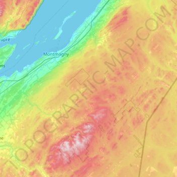
Name: Montmagny (MRC) topographic map, elevation, terrain.
Location: Montmagny (MRC), Chaudière-Appalaches, Quebec, Canada (46.46422 -70.81621 47.20685 -69.96067)
Average elevation: 311 m
Minimum elevation: -2 m
Maximum elevation: 914 m
Make a donation
Other topographic maps
Click on a map to view its topography, its elevation and its terrain.
Mount Royal Park
Canada > Quebec > Urban agglomeration of Montreal > Montreal
The mountain is part of the Monteregian Hills situated between the Laurentians and the Appalachian Mountains. It gave its Latin name, Mons Regius, to the Monteregian chain. The mountain consists of three peaks: Colline de la Croix (or Mont Royal proper) at 233 m (764 ft), Colline d'Outremont (or Mount Murray,…
Average elevation: 110 m
Mount Royal
Canada > Quebec > Urban agglomeration of Montreal > Montreal
The hill is part of the Monteregian Hills situated between the Laurentians and the Appalachian Mountains. It gave its Latin name, Mons Regius, to the Monteregian chain. The hill consists of three peaks: Colline de la Croix (or Mont Royal proper) at 233 m (764 ft), Colline d'Outremont (or Mount Murray, in the…
Average elevation: 111 m
Make a donation
Make a donation
Make a donation
Quebec
Canada > Quebec > Urban agglomeration of Québec
Quebec City was built on the north bank of the Saint Lawrence River, where it narrows and meets the mouth of the Saint-Charles River. Old Quebec is located on top and at the foot of Cap-Diamant, which is on the eastern edge of a plateau called the promontory of Quebec (Quebec hill). Because of this topographic…
Average elevation: 100 m
Make a donation
Magdalen Islands
Canada > Quebec > Urban agglomeration of Les Îles-de-la-Madeleine
Average elevation: 1 m
Make a donation
Make a donation
Make a donation
Make a donation
Lac Saint-Thomas
Canada > Quebec > La Jacques-Cartier > Stoneham-et-Tewkesbury
Average elevation: 505 m
Make a donation
Make a donation
Make a donation
Chisasibi (partie Inuit)
Canada > Quebec > Jamésie > Chisasibi (Land) > Chisasibi
Average elevation: 11 m
Make a donation
Make a donation
Make a donation
Make a donation
Make a donation
Saint-Marc-du-Lac-Long
Canada > Quebec > Témiscouata > Saint-Marc-du-Lac-Long
Average elevation: 258 m
Make a donation
Make a donation
Saint-Louis-de-Masham
Canada > Quebec > Les Collines-de-l'Outaouais > La Pêche
Average elevation: 186 m
Make a donation
Make a donation
Scouts Canada - Lake Lovering Scouts Reserve
Canada > Quebec > Memphrémagog > Magog
Average elevation: 260 m
Madeleine-Centre
Canada > Quebec > La Haute-Gaspésie > Sainte-Madeleine-de-la-Rivière-Madeleine
Average elevation: 72 m
Make a donation
Make a donation
Rivière-la-Madeleine
Canada > Quebec > La Haute-Gaspésie > Sainte-Madeleine-de-la-Rivière-Madeleine
Average elevation: 46 m
Make a donation
Gault Nature Reserve
Canada > Quebec > La Vallée-du-Richelieu > Mont-Saint-Hilaire
Average elevation: 189 m
Make a donation
Parc Léon-Provancher
Canada > Quebec > Urban agglomeration of Montreal > Montreal
Average elevation: 53 m
Make a donation