
Linköpings kommun topographic map
Interactive map
Click on the map to display elevation.
About this map
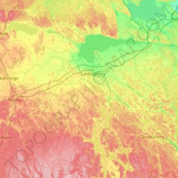
Name: Linköpings kommun topographic map, elevation, terrain.
Location: Linköpings kommun, Provinz Östergötland, Schweden (58.06293 15.25555 58.65219 16.07527)
Average elevation: 99 m
Minimum elevation: 6 m
Maximum elevation: 236 m
Other topographic maps
Click on a map to view its topography, its elevation and its terrain.
Motala kommun
Schweden > Provinz Östergötland
Motala kommun, Provinz Östergötland, Schweden
Average elevation: 100 m
Kinda kommun
Schweden > Provinz Östergötland
Kinda kommun, Provinz Östergötland, Schweden
Average elevation: 133 m