
Motala kommun topographic map
Interactive map
Click on the map to display elevation.
About this map
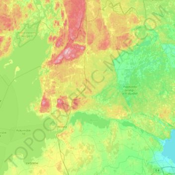
Name: Motala kommun topographic map, elevation, terrain.
Location: Motala kommun, Provinz Östergötland, Schweden (58.41759 14.67344 58.86509 15.49883)
Average elevation: 100 m
Minimum elevation: 32 m
Maximum elevation: 252 m
Other topographic maps
Click on a map to view its topography, its elevation and its terrain.
Kinda kommun
Schweden > Provinz Östergötland
Kinda kommun, Provinz Östergötland, Schweden
Average elevation: 133 m
Linköpings kommun
Schweden > Provinz Östergötland
Linköpings kommun, Provinz Östergötland, Schweden
Average elevation: 99 m