
Province of Lima topographic map
Interactive map
Click on the map to display elevation.
About this map
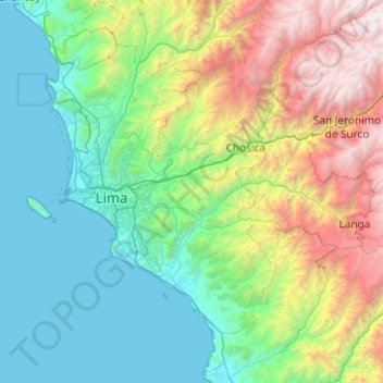
Name: Province of Lima topographic map, elevation, terrain.
Location: Province of Lima, Lima, Peru (-12.51993 -77.19921 -11.57244 -76.62082)
Average elevation: 1,234 m
Minimum elevation: 0 m
Maximum elevation: 5,209 m
Other topographic maps
Click on a map to view its topography, its elevation and its terrain.
Villa El Salvador
Peru > Lima > Villa El Salvador
Villa El Salvador, Province of Lima, Lima, Peru
Average elevation: 104 m
Independencia
Peru > Lima > Independencia
Independencia, Province of Lima, Lima, Peru
Average elevation: 224 m
Pueblo Libre
Peru > Lima > Pueblo Libre
Pueblo Libre, Province of Lima, Lima, Peru
Average elevation: 83 m
Zona Reservada Cordillera Huayhuash
Zona Reservada Cordillera Huayhuash, cutambo pass and siula grande view point, Cajatambo, Lima, Peru
Average elevation: 4,319 m
San Vicente de Cañete
Peru > Lima > San Vicente de Cañete
San Vicente de Cañete, Cañete, Lima, Peru
Average elevation: 85 m
Cieneguilla
Peru > Lima > Cieneguilla
Cieneguilla, Province of Lima, Lima, Peru
Average elevation: 879 m