
Thank you for supporting this site ❤️
Make a donation
Make a donation
Urbanhafen topographic map
Click on the map to display elevation.
Thank you for supporting this site ❤️
Make a donation
Make a donation
About this map
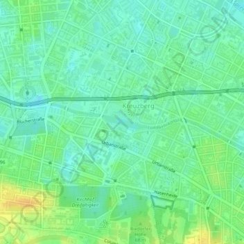
Name: Urbanhafen topographic map, elevation, terrain.
Average elevation: 43 m
Minimum elevation: 32 m
Maximum elevation: 60 m
Thank you for supporting this site ❤️
Make a donation
Make a donation
Other topographic maps
Click on a map to view its topography, its elevation and its terrain.
Berlin
Deutschland > Berlin > Berlin
Die Stadt befindet sich in der gemäßigten Klimazone am Übergang vom maritimen zum kontinentalen Klima. Die durchschnittliche Jahrestemperatur in Berlin-Dahlem beträgt 9,5 °C und die mittlere jährliche Niederschlagsmenge 591 mm. Die wärmsten Monate sind Juli und August mit durchschnittlich 19,1…
Average elevation: 47 m