
Thank you for supporting this site ❤️
Make a donation
Make a donation
Lübarser Höhe topographic map
Click on the map to display elevation.
Thank you for supporting this site ❤️
Make a donation
Make a donation
About this map
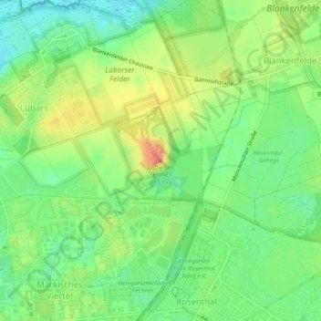
Name: Lübarser Höhe topographic map, elevation, terrain.
Location: Lübarser Höhe, Berlin, 13158, Deutschland (52.61014 13.37048 52.61024 13.37058)
Average elevation: 51 m
Minimum elevation: 30 m
Maximum elevation: 76 m
Thank you for supporting this site ❤️
Make a donation
Make a donation
Other topographic maps
Click on a map to view its topography, its elevation and its terrain.
Lützowplatz
Deutschland > Berlin > Berlin
Die Schillstraße wurde auf Höhe des Platzes am 8. September 1929 ebenfalls in Lützowplatz umbenannt.
Average elevation: 40 m
Thank you for supporting this site ❤️
Make a donation
Make a donation