
佛山市 topographic map
Interactive map
Click on the map to display elevation.
About this map
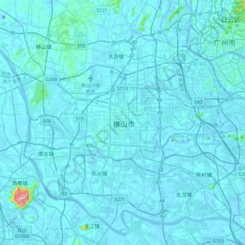
Name: 佛山市 topographic map, elevation, terrain.
Location: 佛山市, 禅城区, 佛山市, 广东省, 528000, 中国 (22.86477 112.95463 23.18477 113.27463)
Average elevation: 8 m
Minimum elevation: -18 m
Maximum elevation: 319 m
佛山市位于中国广东省中南部,地处珠江三角洲腹地。地形平坦,河网交错,土壤肥沃。东倚广州,南邻港、澳,地理位置优越。佛山由于临近海洋,气候温和,温暖多雨,四季常绿,自古就是富饶的鱼米之乡。属亚热带季风气候,年均降水1490.6毫米,年均温22.1℃。低山丘陵多发育红壤、赤红壤,有少量黄壤,平原则为水稻土、堆叠土。自然资源主要有陶土、玻璃砂、稀有金属和水稻、甘蔗及品种繁多的水果、花卉、江河水产资源等。珠江水系中的西江、北江及其支流贯穿全境。
Other topographic maps
Click on a map to view its topography, its elevation and its terrain.