Geolocate

Hallandsåsen topographic map

Click on the map to display elevation.

About this map

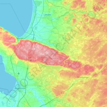
Name: Hallandsåsen topographic map, elevation, terrain.

Location: Hallandsåsen, Skåne County, 286 92, Sweden (56.27828 12.73821 56.46228 13.44829)

Average elevation: 71 m

Minimum elevation: -1 m

Maximum elevation: 222 m

Other topographic maps

Click on a map to view its topography, its elevation and its terrain.

Stockholm

Sweden > Stockholm County

Average elevation: 26 m

Malmö

Sweden > Skåne County > Malmö

Average elevation: 15 m

Uppsala

Sweden > Uppsala County

Situated on the fertile Uppsala flatlands of muddy soil, the city features the small Fyris River (Fyrisån) flowing through the landscape surrounded by lush vegetation. Parallel to the river runs the glacial ridge of Uppsalaåsen at an elevation around 30 m (98 ft), the site of Uppsala's castle, from which…

Average elevation: 29 m

Lund

Sweden > Skåne County

Average elevation: 42 m

Kiruna

Sweden > Norrbotten County

Kiruna is located in the north of Sweden, 145 kilometres (90 mi) north of the Arctic circle. The city centre is built on the Haukavaara hill at an altitude of 530 m, high above the Torne river to the north and the Kalix river to the south. Other parts of the town are Lombolo and Tuolluvaara. Near Kiruna are…

Average elevation: 511 m

Skåne County

Sweden

Average elevation: 44 m

Stockholm

Sweden > Västra Götaland County > Stockholm

Average elevation: 79 m

Ludvika

Sweden > Dalarna County

Average elevation: 184 m

Stutt

Sweden > Dalarna County > Venjan

Average elevation: 295 m

Falkenberg

Sweden > Halland County

Average elevation: 13 m

Ekeberg

Sweden > Jönköping County > Habo

Average elevation: 180 m

Möckeln

Sweden > Kronoberg County > Pjätteryd

Average elevation: 142 m

Umeå

Sweden > Västerbotten County

Average elevation: 50 m

Scandinavia

Sweden

Average elevation: 125 m

Dimmö

Sweden > Jönköping County

Average elevation: 206 m

Boden

Sweden > Norrbotten County

Average elevation: 31 m

Västersjö

Sweden > Uppsala County

Average elevation: 22 m

Gothenburg

Sweden > Västra Götaland County

Average elevation: 45 m

Emmislöv

Sweden > Skåne County > Broby

Average elevation: 37 m

Skede

Sweden > Jönköping County

Average elevation: 176 m

Skälsebo

Sweden > Kalmar County

Average elevation: 50 m

Örtofta

Sweden > Skåne County > Väggarp

Average elevation: 31 m

Moheda

Sweden > Kronoberg County

Average elevation: 179 m

Västmanland County

Sweden

Average elevation: 75 m

Hedalen

Sweden > Västra Götaland County

Average elevation: 189 m

Jönköping

Sweden > Jönköping County

Jönköping's climate was humid continental (Köppen Dfb) with long, cold winters and short, warm summers during the 1961–1990 period. However, the window between subarctic and oceanic is very small in this marine-influenced climate type, and in recent years the climate has more resembled very cold oceanic.…

Average elevation: 215 m

Satsarp

Sweden > Skåne County

Average elevation: 119 m

Pålsboda

Sweden > Örebro County

Average elevation: 91 m

Storumans kommun

Sweden > Västerbotten County

Average elevation: 588 m

Kronoberg County

Sweden

Average elevation: 154 m

Bygården

Sweden > Västra Götaland County

Average elevation: 103 m

Djursholm

Sweden > Stockholm County

Average elevation: 14 m

Hällbo

Sweden > Gävleborg County

Average elevation: 115 m

Strömsnäsbruk

Sweden > Kronoberg County

Average elevation: 133 m

Smögen

Sweden > Västra Götaland County

Average elevation: 4 m

Norberg

Sweden > Västmanland County

Average elevation: 163 m

Gotland

Sweden

Average elevation: 6 m

Sandhem

Sweden > Jönköping County

Average elevation: 242 m

Luleå

Sweden > Norrbotten County

Average elevation: 11 m

Visby

Sweden > Gotland County

Average elevation: 23 m

Tranås

Sweden > Jönköping County

Average elevation: 185 m

Ystad

Sweden > Skåne County

Average elevation: 14 m

Sundsvall

Sweden > Västernorrland County

Average elevation: 70 m

Kristianstad

Sweden > Skåne County

Average elevation: 6 m

Västerås

Sweden > Västmanland County

Average elevation: 28 m

Ingatorp

Sweden > Jönköping County

Average elevation: 197 m

Nacka kommun

Sweden > Stockholm County

Average elevation: 24 m

Stockholm

Sweden > Stockholm County

Average elevation: 26 m

Sigtuna kommun

Sweden > Stockholm County

Average elevation: 26 m

Skanör med Falsterbo

Sweden > Skåne County

Average elevation: 0 m

Orrefors

Sweden > Kalmar County

Average elevation: 164 m

Umeå

Sweden > Västerbotten County

Average elevation: 33 m

Kalmar

Sweden > Kalmar County

Average elevation: 17 m

Sarek

Sweden

Sarek National Park is the most mountainous region in Sweden and it is the part of the country that mostly resembles an alpine countryside. Within the park are 19 summits higher than 1,900 m (6,200 ft), the most noted being the second highest summit in Sweden after the Kebnekaise – the Sarektjåkkå with a…

Average elevation: 994 m

Esrange Space Center

Sweden > Norrbotten County > Jukkasjärvi

Esrange Space Center is a rocket range and research centre located about 40 kilometers east of the town of Kiruna in northern Sweden. It is a base for scientific research with high-altitude balloons, investigation of the aurora borealis, sounding rocket launches, and satellite tracking, among other things.…

Average elevation: 332 m

Botkyrka kommun

Sweden > Stockholm County

Average elevation: 41 m

Norrköping

Sweden > Östergötland County

Average elevation: 49 m

Helsingborg

Sweden > Skåne County

Average elevation: 22 m

Arjeplog

Sweden > Norrbotten County

Average elevation: 443 m

Scandinavian Peninsula

Sweden > Jämtland County

Its highest elevation was Glittertinden in Norway at 2,470 m (8,104 ft) above sea level, but since the glacier at its summit partially melted, the highest elevation is at 2,469 m (8,100 ft) at Galdhøpiggen, also in Norway. These mountains also have the largest glacier on the mainland of Europe, Jostedalsbreen.

Average elevation: 577 m

Gotland

Sweden

Average elevation: 6 m

Falun

Sweden > Dalarna County

Average elevation: 184 m

Karlskoga

Sweden > Örebro County

Karlskoga straddles the northern shore of Lake Möckeln. Among the city's main topographical features are the two rivers, Timsälven and Svartälven. Other features include an esker, Rävåsen, designated as a nature reserve, and contiguous with the city center.

Average elevation: 124 m

Jokkmokk

Sweden > Norrbotten County

Influenced by its inland and northerly position, Jokkmokk's variety of a subarctic climate (Dfc) is very cold by Swedish standards. Summers are normally relatively mild, with midnight sun, and the dark winters are long and cold, although polar night is not quite observed with a sun angle of 0.4° at the winter…

Average elevation: 293 m

Gotland

Sweden

Average elevation: 6 m

Gamla stan

Sweden > Stockholm County > Stockholm

Average elevation: 19 m

Åre

Sweden > Jämtland County

Average elevation: 590 m

Helgasjön

Sweden > Kronoberg County > Åby

Average elevation: 173 m

North Sweden

Sweden

Average elevation: 244 m

Storuman

Sweden > Västerbotten County

Average elevation: 372 m

Gotland

Sweden

Average elevation: 6 m

Kurravaara

Sweden > Norrbotten County

Average elevation: 354 m

Ven

Sweden > Skåne County

Along the entire coast, the island drops steeply towards the sea where the Öresund meets a rocky beach. This steep coast is called Backafall. Ven's backafall is a nature reserve established in 1990. There are no large forests, but smaller stands of trees occur closest to the coast the slightly higher…

Average elevation: 13 m

Gränna

Sweden

Average elevation: 164 m

Kallebäck

Sweden > Västra Götaland County

Average elevation: 52 m

Marks kommun

Sweden > Västra Götaland County

Average elevation: 126 m

Täby kommun

Sweden > Stockholm County

Average elevation: 21 m

Sankt Olof

Sweden > Skåne County

Average elevation: 130 m

Västra Götaland County

Sweden

Average elevation: 97 m

Södertälje

Sweden > Stockholm County

Due to its topography and the fact that it is divided by a canal, it has been difficult to build good train connections in and through the city. Despite this, Södertälje is one of the largest railway hubs in Sweden. When the railway to Södertälje was commissioned, it was decided that the main line would…

Average elevation: 32 m

Province of Västergötland

Sweden

Average elevation: 126 m

Sturefors

Sweden > Östergötland County

Average elevation: 81 m

Fagersta kommun

Sweden > Västmanland County

Average elevation: 131 m

Linköping

Sweden > Östergötland County

Average elevation: 76 m

Södermalm

Sweden > Stockholm County > Stockholm

Average elevation: 22 m

Koppom

Sweden > Värmland County

Average elevation: 183 m

Klippans kommun

Sweden > Skåne County

Average elevation: 75 m

Viggsö

Sweden > Stockholm County > Stagneudd

Average elevation: 5 m

Kiruna

Sweden > Norrbotten County

Average elevation: 472 m

Skånehatten

Sweden > Skåne County

Average elevation: 169 m

Vega

Sweden > Stockholm County

Average elevation: 43 m

Kivik

Sweden > Skåne County

Average elevation: 40 m

Skellefteå

Sweden > Västerbotten County

Average elevation: 49 m

Västerås

Sweden > Västmanland County

Västerås is predominantly known as an industrial city, but also a retailing and logistics city. The city wants to distinguish itself as Västerås – Mälarstaden, meaning "Västerås—the city by Lake Mälaren", in order to attract tourists and new residents, as well as students to the local university,…

Average elevation: 28 m

Grevie

Sweden > Skåne County

Average elevation: 101 m