
Thank you for supporting this site ❤️
Make a donation
Make a donation
Enugu South topographic map
Click on the map to display elevation.
Thank you for supporting this site ❤️
Make a donation
Make a donation
About this map
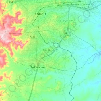
Name: Enugu South topographic map, elevation, terrain.
Location: Enugu South, Enugu State, Nigeria (6.37023 7.44087 6.42829 7.58147)
Average elevation: 193 m
Minimum elevation: 107 m
Maximum elevation: 438 m
Thank you for supporting this site ❤️
Make a donation
Make a donation
Other topographic maps
Click on a map to view its topography, its elevation and its terrain.