
Thank you for supporting this site ❤️
Make a donation
Make a donation
Chisasibi (Village) topographic map
Click on the map to display elevation.
Thank you for supporting this site ❤️
Make a donation
Make a donation
About this map
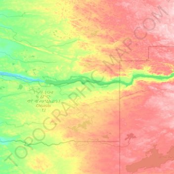
Name: Chisasibi (Village) topographic map, elevation, terrain.
Average elevation: 96 m
Minimum elevation: 1 m
Maximum elevation: 206 m
Thank you for supporting this site ❤️
Make a donation
Make a donation
Other topographic maps
Click on a map to view its topography, its elevation and its terrain.
Chisasibi (partie Inuit)
Canada > Quebec > Jamésie > Chisasibi (Land) > Chisasibi
Average elevation: 11 m
Thank you for supporting this site ❤️
Make a donation
Make a donation
Thank you for supporting this site ❤️
Make a donation
Make a donation
Lebel-sur-Quévillon
Canada > Quebec > Jamésie > Lebel-sur-Quévillon > Lebel-sur-Quévillon
Average elevation: 285 m
Thank you for supporting this site ❤️
Make a donation
Make a donation