
Thank you for supporting this site ❤️
Make a donation
Make a donation
Île Trailer topographic map
Click on the map to display elevation.
Thank you for supporting this site ❤️
Make a donation
Make a donation
About this map
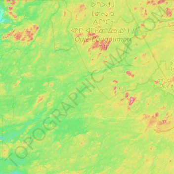
Name: Île Trailer topographic map, elevation, terrain.
Average elevation: 359 m
Minimum elevation: 304 m
Maximum elevation: 537 m
Thank you for supporting this site ❤️
Make a donation
Make a donation
Other topographic maps
Click on a map to view its topography, its elevation and its terrain.
Thank you for supporting this site ❤️
Make a donation
Make a donation
Thank you for supporting this site ❤️
Make a donation
Make a donation
Lac Sakami
Lac Sakami is now a reservoir of the James Bay Project with a depth of 113 m (371 ft), an elevation of 186 m (610 ft) and an area of 738 km2 (285 sq mi). Prior to being used as a reservoir it had an area of 533 km2 (206 sq mi). The Cree called the lake Mesackamee.
Average elevation: 202 m
Thank you for supporting this site ❤️
Make a donation
Make a donation
Thank you for supporting this site ❤️
Make a donation
Make a donation