
Southwestern Ontario topographic map
Interactive map
Click on the map to display elevation.
About this map
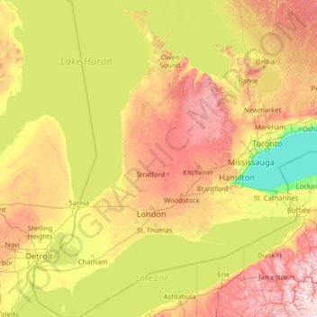
Name: Southwestern Ontario topographic map, elevation, terrain.
Location: Southwestern Ontario, Ontario, Canada (41.67656 -83.14969 45.36223 -79.29661)
Average elevation: 235 m
Minimum elevation: 72 m
Maximum elevation: 719 m
Other topographic maps
Click on a map to view its topography, its elevation and its terrain.
Uxbridge
Canada > Ontario > Durham Region
Uxbridge, Durham Region, Golden Horseshoe, Ontario, Canada
Average elevation: 284 m
Calm Lake
Canada > Ontario > Rainy River District > Unorganized Rainy River
Calm Lake, Unorganized Rainy River, Rainy River District, Northwestern Ontario, Ontario, Canada
Average elevation: 391 m
Niagara Falls
Canada > Ontario > Niagara Region
Niagara Falls, Niagara Region, Golden Horseshoe, Ontario, Canada
Average elevation: 179 m
Nobleton
Canada > Ontario > York Region > King
Nobleton, King, York Region, Golden Horseshoe, Ontario, L0G 1N0, Canada
Average elevation: 264 m
York
Canada > Ontario > Haldimand County
York, Haldimand County, Ontario, Canada
Average elevation: 197 m
The Blue Mountains
Canada > Ontario > Grey County
The Blue Mountains, Grey County, Ontario, N0H 2P0, Canada
Average elevation: 265 m
Sauble Beach
Canada > Ontario > Bruce County
Sauble Beach, South Bruce Peninsula, Bruce County, Ontario, N0H 2G0, Canada
Average elevation: 188 m
Waterford
Canada > Ontario > Norfolk County > Waterford
Waterford, Norfolk County, Ontario, N0E 1Y0, Canada
Average elevation: 241 m
Domville
Canada > Ontario > Leeds and Grenville Counties > Augusta
Domville, Augusta, Leeds and Grenville Counties, Eastern Ontario, Ontario, K0E 1X0, Canada
Average elevation: 103 m
Negeek Lake
Canada > Ontario > Renfrew County > Madawaska Valley > Combermere
Negeek Lake, Combermere, Madawaska Valley, Renfrew County, Eastern Ontario, Ontario, Canada
Average elevation: 306 m
Loveland Lake
Canada > Ontario > Kenora District > Unorganized Kenora District
Loveland Lake, Unorganized Kenora District, Kenora District, Northwestern Ontario, Ontario, Canada
Average elevation: 426 m
Ellsmere Island
Canada > Ontario > Parry Sound District > The Archipelago Township
Ellsmere Island, The Archipelago Township, Parry Sound District, Central Ontario, Ontario, Canada
Average elevation: 197 m
Hubbard Creek
Canada > Ontario > Sudbury District > Unorganized North Sudbury
Hubbard Creek, Unorganized North Sudbury, Sudbury District, Northeastern Ontario, Ontario, Canada
Average elevation: 457 m
Niagara Peninsula
Canada > Ontario > Niagara Region
Niagara Peninsula, Niagara Region, Golden Horseshoe, Ontario, Canada
Average elevation: 164 m
Kapuskasing
Canada > Ontario > Cochrane District
Kapuskasing, Cochrane District, Northeastern Ontario, Ontario, Canada
Average elevation: 227 m
Clarksburg
Canada > Ontario > Grey County > The Blue Mountains
Clarksburg, The Blue Mountains, Grey County, Ontario, N0H 1J0, Canada
Average elevation: 211 m
Embrun
Canada > Ontario > Prescott and Russell Counties
Embrun, Russell, Prescott and Russell Counties, Eastern Ontario, Ontario, K0A 1W1, Canada
Average elevation: 69 m
West Grey
Canada > Ontario > Grey County
West Grey, Grey County, Ontario, Canada
Average elevation: 357 m
Chalk River
Canada > Ontario > Renfrew County
Chalk River, Laurentian Hills, Renfrew County, Eastern Ontario, Ontario, Canada
Average elevation: 158 m
Cold Springs
Canada > Ontario > Northumberland County > Hamilton Township
Cold Springs, Hamilton Township, Northumberland County, Central Ontario, Ontario, K9A 0L8, Canada
Average elevation: 249 m
North Grenville
Canada > Ontario > Leeds and Grenville Counties
North Grenville, Leeds and Grenville Counties, Eastern Ontario, Ontario, Canada
Average elevation: 98 m
Kemble
Canada > Ontario > Grey County > Georgian Bluffs
Kemble, Georgian Bluffs, Grey County, Ontario, Canada
Average elevation: 243 m
Orangeville
Canada > Ontario > Dufferin County
Orangeville, Dufferin County, Central Ontario, Ontario, Canada
Average elevation: 444 m
Grey Highlands
Canada > Ontario > Grey County
Grey Highlands, Grey County, Ontario, Canada
Average elevation: 428 m
Kellow Lake
Canada > Ontario > Thunder Bay District > Unorganized Thunder Bay District
Kellow Lake, Unorganized Thunder Bay District, Thunder Bay District, Northwestern Ontario, Ontario, Canada
Average elevation: 294 m
P.E.I.
Canada > Ontario > Kenora District > Unorganized Kenora District
P.E.I., Unorganized Kenora District, Kenora District, Northwestern Ontario, Ontario, Canada
Average elevation: 317 m
Killarney Provincial Park
Killarney Provincial Park, Chikanishing Creek Road, Killarney, Sudbury District, Northeastern Ontario, Ontario, P0M 2A0, Canada
Average elevation: 185 m
Muskoka District
Muskoka District, Central Ontario, Ontario, Canada
Average elevation: 294 m
Leeds and Grenville
Canada > Ontario > Leeds and Grenville Counties
Leeds and Grenville, Leeds and Grenville Counties, Eastern Ontario, Ontario, Canada
Average elevation: 146 m
Lochlin Lake
Canada > Ontario > Haliburton County > Highlands East
Lochlin Lake, Highlands East, Haliburton County, Central Ontario, Ontario, Canada
Average elevation: 365 m
Halton Hills
Canada > Ontario > Halton Region
Halton Hills, Halton Region, Golden Horseshoe, Ontario, L7G 5W1, Canada
Average elevation: 287 m
Richmond Hill
Canada > Ontario > York Region
Richmond Hill, York Region, Golden Horseshoe, Ontario, Canada
Average elevation: 256 m
Newbury
Canada > Ontario > Middlesex County
Newbury, Middlesex County, Ontario, N0L 1Z0, Canada
Average elevation: 213 m
Sault Ste. Marie
Canada > Ontario > Algoma District
Sault Ste. Marie, Algoma District, Northeastern Ontario, Ontario, Canada
Average elevation: 249 m
Apple Hill
Canada > Ontario > Stormont, Dundas and Glengarry Counties > North Glengarry
Apple Hill, North Glengarry, Stormont, Dundas and Glengarry Counties, Eastern Ontario, Ontario, K0C 1B0, Canada
Average elevation: 90 m
Newboro
Canada > Ontario > Leeds and Grenville Counties > Rideau Lakes
Newboro, Rideau Lakes, Leeds and Grenville Counties, Eastern Ontario, Ontario, K0G 1P0, Canada
Average elevation: 127 m
Sioux Lookout
Canada > Ontario > Kenora District
Sioux Lookout, Kenora District, Northwestern Ontario, Ontario, Canada
Average elevation: 363 m
Leamington
Canada > Ontario > Essex County
Leamington, Essex County, Ontario, Canada
Average elevation: 177 m
Davenport
Canada > Ontario > Old Toronto
Davenport, Old Toronto, Toronto, Golden Horseshoe, Ontario, Canada
Average elevation: 124 m
Central Manitoulin
Canada > Ontario > Manitoulin District
Central Manitoulin, Manitoulin District, Northeastern Ontario, Ontario, Canada
Average elevation: 185 m
Atikokan
Canada > Ontario > Rainy River District
Atikokan, Rainy River District, Northwestern Ontario, Ontario, Canada
Average elevation: 422 m
Lindsay
Canada > Ontario > Kawartha Lakes
Lindsay, Kawartha Lakes, Central Ontario, Ontario, K9V 2Y5, Canada
Average elevation: 268 m
Caledon
Canada > Ontario > Peel Region
Caledon, Peel Region, Golden Horseshoe, Ontario, L7C 2Z2, Canada
Average elevation: 311 m