
Make a donation
Orillia topographic map
Click on the map to display elevation.
Make a donation
About this map
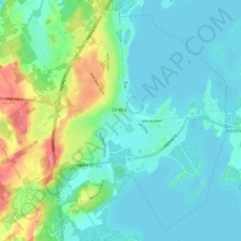
Name: Orillia topographic map, elevation, terrain.
Location: Orillia, Central Ontario, Ontario, Canada (44.56717 -79.47570 44.64419 -79.36930)
Average elevation: 234 m
Minimum elevation: 215 m
Maximum elevation: 293 m
Make a donation
Other topographic maps
Click on a map to view its topography, its elevation and its terrain.
Toronto
Despite its deep ravines, Toronto is not remarkably hilly, but its elevation does increase steadily away from the lake. Elevation differences range from 76.5 metres (251 ft) above sea level at the Lake Ontario shore to 209 m (686 ft) ASL near the York University grounds in the city's north end at the…
Average elevation: 113 m
Make a donation
Make a donation
Ellsmere Island
Canada > Ontario > Parry Sound District > The Archipelago Township
Average elevation: 197 m
Make a donation
St. Helena Island
Canada > Ontario > Leeds and Grenville Counties > Front of Yonge
Average elevation: 115 m
Pittston
Canada > Ontario > Leeds and Grenville Counties > Edwardsburgh/Cardinal
Average elevation: 82 m
Make a donation
Slate Islands
Canada > Ontario > Kenora District > Unorganized Kenora District
Average elevation: 322 m
Galbraith Lake
Canada > Ontario > Kenora District > Unorganized Kenora District
Average elevation: 455 m
Make a donation
Morewood
Canada > Ontario > Stormont, Dundas and Glengarry Counties > North Dundas
Average elevation: 77 m
Sesekinika
Canada > Ontario > Timiskaming District > Unorganized West Timiskaming
Average elevation: 320 m
Make a donation
Ellery Lake
Canada > Ontario > Cochrane District > Unorganized North Cochrane
Average elevation: 350 m
Make a donation
Make a donation
La Cloche Mountains
Canada > Ontario > Sudbury District > Sables-Spanish Rivers Township
Average elevation: 337 m
Opeongo Lake Dam
Canada > Ontario > Nipissing District > Unorganized South Nipissing
Average elevation: 419 m
Cedar Island
Canada > Ontario > Algoma District > Plummer Additional Township
Average elevation: 216 m
Make a donation
Echo Lake
Canada > Ontario > Timiskaming District > Unorganized West Timiskaming
Average elevation: 339 m
Make a donation
Make a donation
Make a donation
Apple Hill
Canada > Ontario > Stormont, Dundas and Glengarry Counties > North Glengarry
Average elevation: 90 m
Make a donation
Kellow Lake
Canada > Ontario > Thunder Bay District > Unorganized Thunder Bay District
Average elevation: 294 m
Make a donation
Loveland Lake
Canada > Ontario > Kenora District > Unorganized Kenora District
Average elevation: 426 m
Make a donation
Berwick
Canada > Ontario > Stormont, Dundas and Glengarry Counties > North Stormont
Average elevation: 75 m
Make a donation
Make a donation
Alexandria
Canada > Ontario > Stormont, Dundas and Glengarry Counties > North Glengarry
Average elevation: 84 m
Make a donation
Hubbard Creek
Canada > Ontario > Sudbury District > Unorganized North Sudbury
Average elevation: 457 m
Make a donation
Make a donation
Make a donation
Bala Park Island
Canada > Ontario > Muskoka District > Muskoka Lakes Township > Bala
Average elevation: 228 m
Make a donation
Make a donation
Iroquois
Canada > Ontario > Stormont, Dundas and Glengarry Counties > South Dundas
Average elevation: 83 m
Cockburn Island
Canada > Ontario > Leeds and Grenville Counties > Elizabethtown-Kitley
Average elevation: 112 m
Make a donation
Make a donation