
Thank you for supporting this site ❤️
Make a donation
Make a donation
Dinner Lake topographic map
Click on the map to display elevation.
Thank you for supporting this site ❤️
Make a donation
Make a donation
About this map
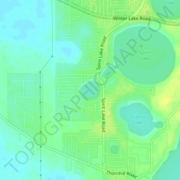
Name: Dinner Lake topographic map, elevation, terrain.
Location: Dinner Lake, Polk County, Florida, United States (27.99255 -81.78826 27.99535 -81.78479)
Average elevation: 41 m
Minimum elevation: 33 m
Maximum elevation: 52 m
Thank you for supporting this site ❤️
Make a donation
Make a donation
Other topographic maps
Click on a map to view its topography, its elevation and its terrain.
Thank you for supporting this site ❤️
Make a donation
Make a donation
Thank you for supporting this site ❤️
Make a donation
Make a donation
Thank you for supporting this site ❤️
Make a donation
Make a donation