
Make a donation
Brewster topographic map
Click on the map to display elevation.
Make a donation
About this map
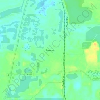
Name: Brewster topographic map, elevation, terrain.
Location: Brewster, Polk County, Florida, United States (27.73281 -81.99953 27.77281 -81.95953)
Average elevation: 42 m
Minimum elevation: 32 m
Maximum elevation: 62 m
Make a donation
Other topographic maps
Click on a map to view its topography, its elevation and its terrain.
Make a donation
Make a donation
Colt Creek State Park
United States > Florida > Polk County
The park's habitat consist primarily of mesic flatwoods co-dominated by cypress domes, hardwood hammocks and wetlands. Lands within the park are relatively flat, with an average elevation of 90 feet above sea level. Additionally, natural-looking lakes that formed from old lime rock mining operations are…
Average elevation: 28 m
Make a donation
Lakeland Highlands
United States > Florida > Polk County > Bartow > Lakeland Highlands
Average elevation: 64 m
Make a donation
Make a donation