Geolocate
👉 Easily get elevation data in JSON, GeoTIFF and KML formats using Elevation API
Thank you for supporting this site ❤️
Make a donation

Karu topographic map

Click on the map to display elevation.

👉 Easily get elevation data in JSON, GeoTIFF and KML formats using Elevation API
Thank you for supporting this site ❤️
Make a donation

About this map

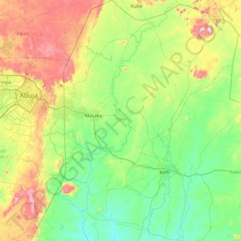
Name: Karu topographic map, elevation, terrain.

Location: Karu, Nasarawa State, Nigeria (8.65198 7.56530 9.32925 8.08724)

Average elevation: 422 m

Minimum elevation: 204 m

Maximum elevation: 978 m

Other topographic maps

Click on a map to view its topography, its elevation and its terrain.

Ukpo

Nigeria > Nasarawa State > Awe > Ukpo

Average elevation: 173 m

Awe

Nigeria > Nasarawa State > Awe

Average elevation: 144 m

Adawa

Nigeria > Nasarawa State > Awe

Average elevation: 165 m