
Thank you for supporting this site ❤️
Make a donation
Make a donation
Losheim am See topographic map
Click on the map to display elevation.
Thank you for supporting this site ❤️
Make a donation
Make a donation
About this map
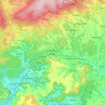
Name: Losheim am See topographic map, elevation, terrain.
Average elevation: 346 m
Minimum elevation: 186 m
Maximum elevation: 629 m
Thank you for supporting this site ❤️
Make a donation
Make a donation
Other topographic maps
Click on a map to view its topography, its elevation and its terrain.
Stausee Losheim
Deutschland > Saarland > Landkreis Merzig-Wadern > Losheim am See
Average elevation: 331 m
Thank you for supporting this site ❤️
Make a donation
Make a donation
Naturschutzgebiet Wadrilltal
Deutschland > Saarland > Landkreis Merzig-Wadern > Wadern
Average elevation: 323 m
Thank you for supporting this site ❤️
Make a donation
Make a donation
Reidelbach
Deutschland > Saarland > Landkreis Merzig-Wadern > Wadern > Wedern
Average elevation: 395 m
Thank you for supporting this site ❤️
Make a donation
Make a donation
Scheiden
Deutschland > Saarland > Landkreis Merzig-Wadern > Losheim am See > Scheiden
Average elevation: 473 m
Rissenthal
Deutschland > Saarland > Landkreis Merzig-Wadern > Losheim am See > Rissenthal
Average elevation: 305 m
Thank you for supporting this site ❤️
Make a donation
Make a donation