

Indre topographic map
Click on the map to display elevation.
Indre
Indre is divided into four natural regions; North Boischaut is undulating land with an altitude between 80 and 215 m (260 and 710 ft) and occupies the northeast of the department, South Boischaut is hilly and lies in the south and southeast, a marshy tract of land known as Brenne is in the southwestern part of the department, and the flat, dry, flinty limestone plateau of Champagne berrichonne is in the east and continues into Cher. The highest point of the department is near the town of Pouligny-Notre-Dame where the land rises to 459 m (1,506 ft) above sea level. The department is made up of 680,910 ha (1,682,600 acres) of land of which 401,535 ha (992,210 acres) are under arable cropping, 85,305 ha (210,790 acres) are grassland, 67,423 ha (166,610 acres) are woodland, 18,110 ha (44,800 acres) are under grapes and 18,273 ha (45,150 acres) are gardens and orchards. The remaining land is heathland, urban land and waterways.
About this map
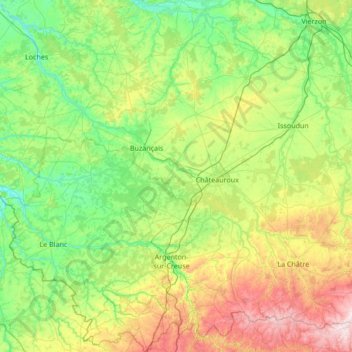
Name: Indre topographic map, elevation, terrain.
Location: Indre, Centre-Val de Loire, Metropolitan France, France (46.34716 0.86711 47.27734 2.20453)
Average elevation: 166 m
Minimum elevation: 60 m
Maximum elevation: 499 m
Other topographic maps
Click on a map to view its topography, its elevation and its terrain.


Maison Forestière des Cordelières
France > Centre-Val de Loire > Loiret > Vitry-aux-Loges
Average elevation: 124 m


Chartres Cathedral
France > Centre-Val de Loire > Eure-et-Loir > Chartres
The elevation of the nave, showing the gallery on the ground level; the narrow triforium; and, on top, the windows of the clerestory
Average elevation: 148 m




Le Grand Village
France > Centre-Val de Loire > Indre-et-Loire > La Ville-aux-Dames
Average elevation: 51 m

Villarceaux
France > Centre-Val de Loire > Eure-et-Loir > Les Villages Vovéens
Average elevation: 151 m
La Feuillarde
France > Centre-Val de Loire > Indre-et-Loire > Saint-Pierre-des-Corps
Average elevation: 55 m




La Diablerie
France > Centre-Val de Loire > Indre-et-Loire > Chanceaux-sur-Choisille
Average elevation: 111 m

La Porte, Château
France > Centre-Val de Loire > Loiret > Autruy-sur-Juine > La Porte
Average elevation: 121 m



Rigaudon
France > Centre-Val de Loire > Loir-et-Cher > Montrichard Val de Cher
Average elevation: 97 m
Pièce du Bois et des Fosses
France > Centre-Val de Loire > Indre > Saint-Maur
Average elevation: 162 m

Terres du Gd Sous Les Vign
France > Centre-Val de Loire > Loiret > Dordives > Le Grand-sous-les-Vignes
Average elevation: 93 m





Le Télégraphe
France > Centre-Val de Loire > Indre-et-Loire > Chambray-lès-Tours
Average elevation: 86 m
Le Clos des Chênes
France > Centre-Val de Loire > Indre-et-Loire > Chouzé-sur-Loire
Average elevation: 30 m

Plateau de Bel-Air
France > Centre-Val de Loire > Loir-et-Cher > Saint-Ouen > Côte de Bel-Air
Average elevation: 105 m

Pièce de la Fosse aux Joncs
France > Centre-Val de Loire > Indre > Saint-Maur
Average elevation: 161 m



La Diablerie
France > Centre-Val de Loire > Indre-et-Loire > Chanceaux-sur-Choisille
Average elevation: 111 m

Chouzy
France > Centre-Val de Loire > Loir-et-Cher > La Chapelle-Saint-Martin-en-Plaine
Average elevation: 115 m


La Pente de l'Aigri
France > Centre-Val de Loire > Loir-et-Cher > Saint-Georges-sur-Cher
Average elevation: 99 m
La Batardière
France > Centre-Val de Loire > Loir-et-Cher > Montrichard Val de Cher
Average elevation: 99 m

²Le Grand Champ
France > Centre-Val de Loire > Indre > Lourouer-Saint-Laurent
Average elevation: 207 m


Le Bois Turbet
France > Centre-Val de Loire > Indre-et-Loire > Marcé-sur-Esves
Average elevation: 82 m