
Thank you for supporting this site ❤️
Make a donation
Make a donation
Woodbine topographic map
Click on the map to display elevation.
Thank you for supporting this site ❤️
Make a donation
Make a donation
About this map
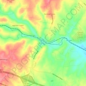
Name: Woodbine topographic map, elevation, terrain.
Location: Woodbine, Carroll County, Maryland, 21797, United States (39.33994 -77.08208 39.37994 -77.04208)
Average elevation: 182 m
Minimum elevation: 132 m
Maximum elevation: 229 m
Thank you for supporting this site ❤️
Make a donation
Make a donation
Other topographic maps
Click on a map to view its topography, its elevation and its terrain.
Avondale Wildlife Management Area
United States > Maryland > Carroll County > Chapel Heights
Average elevation: 206 m
Thank you for supporting this site ❤️
Make a donation
Make a donation