
Make a donation
Greensboro topographic map
Click on the map to display elevation.
Make a donation
Greensboro
Greensboro is characterized by a gently rolling topography, typical of the Piedmont region. The city sits at an elevation of approximately 790 feet (241 meters) above sea level, with its terrain featuring a mix of low hills and valleys that create a varied landscape. The area is bisected by several waterways, including the Haw River and Lake Brandt, which contribute to the region's natural beauty and ecological diversity. This rolling landscape is punctuated by urban development, but parks and green spaces are integral to the city's layout, providing residents with access to nature amidst the suburban environment. The overall elevation and gentle slopes lend themselves to a variety of recreational activities, including hiking and biking along the many trails available in the region.
Make a donation
About this map
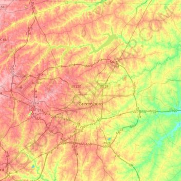
Name: Greensboro topographic map, elevation, terrain.
Location: Greensboro, Guilford County, North Carolina, United States (35.97581 -80.01788 36.21536 -79.62117)
Average elevation: 242 m
Minimum elevation: 171 m
Maximum elevation: 299 m
Make a donation
Other topographic maps
Click on a map to view its topography, its elevation and its terrain.
Make a donation
Sherwood Village
United States > North Carolina > Guilford County > High Point
Average elevation: 262 m
Make a donation
Piedmont Heights
United States > North Carolina > Guilford County > Greensboro
Average elevation: 251 m
Make a donation
Make a donation
Melborne Heights
United States > North Carolina > Guilford County > High Point
Average elevation: 256 m
Make a donation