
Make a donation
Njombe Region topographic map
Click on the map to display elevation.
Make a donation
Njombe Region
The Njombe Region, which is a part of Tanzania's Southern Highlands zone, has extensive rainy seasons and brief dry seasons, which are typically cool with moderate winds. The yearly total rainfall varies greatly geographically, seasonally, and annually, ranging from 600mm to 1,600mm. A single, very distinct rainy season that lasts from November through May is followed by a chilly, dry season that lasts from May to September. Depending on the altitude, the temperature in the area can range from 0°C in May and June to roughly 20°C to 24°C in October and November. Furthermore, there can be significant temperature changes between day and night, with scorching afternoons reaching temperatures of up to 26 °C and chilly evenings and nights reaching temperatures of less than 0 °C.
Make a donation
About this map
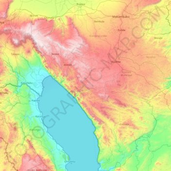
Name: Njombe Region topographic map, elevation, terrain.
Location: Njombe Region, Southern Highlands Zone, Tanzania (-10.54018 33.81174 -8.66511 35.52397)
Average elevation: 1,317 m
Minimum elevation: 471 m
Maximum elevation: 2,931 m
Make a donation
Other topographic maps
Click on a map to view its topography, its elevation and its terrain.
Mwanza
Mwanza features a tropical savanna climate under the Köppen climate classification. Temperatures are relatively consistent throughout the course of the year, tempered by the city's altitude. Thus, the climate is not quite as hot as one might expect, given the city's location near the equator. Average…
Average elevation: 1,178 m
Make a donation
Make a donation