
Make a donation
West Chazy topographic map
Click on the map to display elevation.
Make a donation
About this map
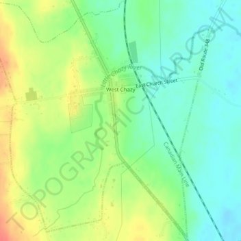
Name: West Chazy topographic map, elevation, terrain.
Average elevation: 85 m
Minimum elevation: 64 m
Maximum elevation: 116 m
Make a donation
Other topographic maps
Click on a map to view its topography, its elevation and its terrain.
Woods Mills
United States > New York > Clinton County > Town of Schuyler Falls
Average elevation: 211 m
Lake Roxanne
United States > New York > Clinton County > Town of Ellenburg > Ellenburg Depot
Average elevation: 280 m
Stevens Landing
United States > New York > Clinton County > Town of Black Brook
Average elevation: 385 m
Make a donation
Make a donation
Make a donation
Ellenburg Center
United States > New York > Clinton County > Town of Ellenburg
Average elevation: 383 m
Ellenburg Depot
United States > New York > Clinton County > Town of Ellenburg
Average elevation: 274 m
Make a donation
Make a donation
Champlain Park
United States > New York > Clinton County > City of Plattsburgh
Average elevation: 37 m
Make a donation
Make a donation
Make a donation
Plattsburg Boat Launch
United States > New York > Clinton County > City of Plattsburgh
Average elevation: 36 m
Make a donation
Upper Chateaugay Lake Sandbar
United States > New York > Clinton County > Town of Ellenburg
Average elevation: 417 m